Visit the new and improved Hamilton Education Program website
1863/11/09
Lincoln, Abraham, 1809-1865
[Early photo of the coin counting room of the Philadelphia Mint]
[Early photo of the coin counting room of the Philadelphia Mint]. A photo of two men sitting at a table counting coins.
GLC01992.02
circa. 1906
Harris & Ewing, fl. 1905-1977
[Photograph of James Sherman]
Photograph of James Sherman. Sherman is wearing a suit and tie, and looking directly at the camera. The signatures of the photographers, Harris and Ewing, are written in pencil at the bottom of the border of the photograph. See one Sherman's letter...
GLC02512.11.02
1783
[A list of 50 names]
A list of 50 names, including both men and women.
GLC02669.038
1 May 1876
to Naomi E. Briggs
This envolope is not accompanied by a letter and is addressed to Miss Naomi E. Briggs in Snow Falls, Maine. The envelope is postmarked from South Waterford, Maine on May 1, 1876.
GLC02669.107
circa 1941
[Burning aircraft carrier flying American flag]
Color image of a burning aircraft carrier flying American flag. Additional American vessel in foreground. Japanese text in caption on right hand side.
GLC09552.09
[Vessel under attack with Japanese planes flying overhead]
Color image of a vessel under attack with Japanese planes flying overhead. Japanese text in caption on right hand side.
GLC09552.10
30 April 1941
Japan Cabinet Printing Bureau
General Map of Greater East Asian Co-prosperity Sphere and Pacific Ocean
Map of territories included in the Japanese propaganda concept, the "Greater East Asian Co-prosperity Sphere." The concept promoted the cultural and economic unity of the region by a self-sufficient bloc of Asian nations led by the Japanese and free...
GLC09552.11
18 April 1942
Tokyo Raider in Hands of Japanese
A black and white photograph of a blindfolded U.S. Army Air Corps officer being led from a plane by two Japanese soldiers. There is a press clipping in the photograph and an block of the photo is obscured by a white bar. The back of the photograph is...
GLC09553.09
From Aerial Umbrella to Chinese Parasols
A black and white photograph of American and Chinese soldiers carrying parasols. A press clipping is a part of the photograph.
GLC09553.10
Chinese Rescue Crashed Shangri-La Bombers
A black and white photograph of Chinese soldiers bringing a group of General Doolittle's raiders in a small village near where their bomber crashed. Featured in the photograph is Colonel John Hilger, who was injured in the crash. Attached to the back...
GLC09553.11
Japanese Picture of Doolittle Fliers
A black and white photograph of U.S. Army Air Corps men in Japan following the Doolittle Raid. Two of the men in the photograph are believed to be Lieutenant Robert Hite and Lieutenant William Farrow. Attached to the back of the photograph is a...
GLC09553.12
Raided Tokyo, Escaped Japanese by Hiding in Cave
A black and white photograph of U.S. Army Air Corps men outside a cave in Japan following the Doolittle Raid. Attached to the back of the photograph is a press clipping describing the photograph with the date April 22, 1943. Removed from an unknown...
GLC09553.13
Gen. Doolittle's Men Hide in a Cave
A black and white photograph of U.S. Army Air Corps men outside a cave in Japan following the Doolittle Raid. Attached to the back of the photograph is a press clipping describing the photograph with the date April 22, 1943. This is a close up of...
GLC09553.14
1941
War Office
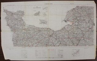
[Map of French coast from Cherbourg to Rouen]
A first edition European road map published by the War Office in 1941, showing the French coast from Cherbourg to Rouen.
GLC09557.01
March 1944
War Department Corps of Engineers, U.S. Army
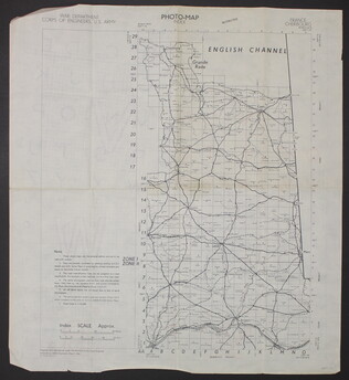
[Photo-map index]
A two-sided photo-map index of the English Channel. One side of the map shows Cherbourg, France, the English Channel, and Grande Rade. There is a grid over the map labled 1 to 29 on the y-axis and A to O on the x-axis. The reverse side of the map...
GLC09557.02
May 1944
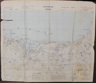
Defenses Cherbourg
A two-sided map of the defenses of Cherbourg, France. The shows the map itself, while the back has a large legend. There is a tear in the upper left quadrant of the map.
GLC09557.03
U.S. Army
Defences Lessay
A two-sided map of the defences of Lessay, France. The front shows the map itself, while the back has a large ledgend.
GLC09557.04
1943
Port en Bessin to Cherbourg [and] Entretat to Port Bessin
A two-sided map of the coastline of France. One side of the map shows the Port en Bessin to Cherbourg and the reverse side shows Entretat to Port Bessin. This map has three hole punches and is labled page 185 and 186, but the rest of the book or...
GLC09557.05
ca. 1944
[Allied invasion of Normandy sectors]
A map of the five areas where Allied troops invaded Normandy on June 6, 1944.
GLC09557.06
September 1943
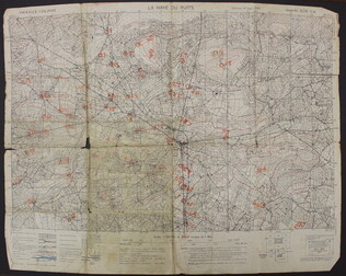
La Haye du Puits [French]
A map of La Haye-du-Puits, France. There are numbers handwritten in orange on the map, but it is unclear what they represent. The back of the map has "La Haye Du Puits 31/18 S.W.," written in red.
GLC09557.07
June 5, 2000-June 18, 2000
Vinch, Chuck, fl. 2000
The Stars and Stripes. [(June 5, 2000) - (June 18, 2000)]
"D-Day: Success and Challenges on the Beaches of Normandy," written by Chuck Vinch, reflects on the reasons behind the success of the Invasion of Normandy. Vinch attributes a large part of the success of the invasion to decieving the German's into...
GLC09557.08
January 1945
United States. Naval Oceanographic Office
France - North Coast: Asnelle to Villers Including Caven Roadstead
A greyscale map of the North coast of France. Originally produced by the French government in 1893 with updates made in 1928, 1930, 1931, 1932, 1934, 1937, and 1938.
GLC09557.09
1894
Northrop, B.G., fl. 1894
The Homes of the Negroes in the South
Essay written by Rev. B.G. Northrop taken from The Congregationalist of April 12, 1894.
GLC09564
4 August 1861
Crans, Adolphus W., fl. 1863-1864
William Crans
GLC06627.01.01
28 July 1861
GLC06627.01.03
Showing results 64351 - 64375