Visit the new and improved Hamilton Education Program website
1846
Preuss, Charles, fl. 1846
Topographical map of the road from Missouri to Oregon
Compiled by Charles Preuss, 1846, by command of the Senate. In Seven Sections. Scale 10 miles to the inch. Litho by E. Weber & Co., Baltimore.
GLC01873
1776
Brassier, William, fl. 1776
A survey of Lake Champlain, including Lake George, Crown Point... 1762
Includes (inset) "A particular plan of Lake George." The engraved map shows engagements between American and British forces on Lake Champlain. Not in Nebenzahl, Battle Plans of the American Revolution.
GLC01874
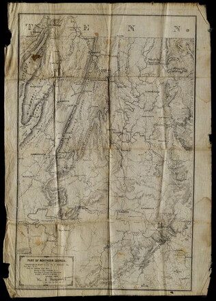
5 May 1864
Margedant, William C., 1835-?
Part of Northern Georgia
Printed "In the field" on cloth. Black and white lithograph depicts Northern Georgia. Compiled under the direction of William E. Merrill, Chief Topographical Engineer, Washington, D.C. Margedant was Captain and Superintendent of the Topographical...
GLC01740.06
2 May 1864
Merrill, W.E., 1837-1891
Map of Northern Georgia.
Created under the direction of Captain William E. Merrill, Chief Topographical Engineer. Lithographed map printed on paper squares mounted on cloth to facilitate folding. Contains handcoloring on roads and state borders. Based on Cherokee land maps...
GLC01740.02
1862
Nicholson, Walter L., ?-1895
Map of Eastern Virginia compiled from the best authorities, and printed at the Coast Survey Office.
Printed by the Coast Survey Office, compiled by Nicholson, and lithographed by Charles G. Krebs. Depicts eastern Virginia, Maryland and Delaware with portions of Pennsylvania, New Jersey, and North Carolina. Shows rail lines, rivers, and other...
GLC01740.03
Showing results 46 - 50