1718
De L'Isle, Guillaume, fl. 1718
Map
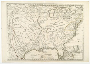
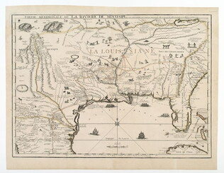
Title: Carte de la Louisiane et du cours du Mississippi [map of North America]
Based on the notes of M. le Maire by Guillaume del'Isle. The first detailed map of the Gulf coast region and the Mississippi, and the first printed map to show Texas. With an insert of Mobile Bay. This map was also the first to show the land routes of earlier explorers: Desoto in 1539 and 1540 and his successor Moscoso in 1542, Cavelier in 1687, Tonty in 1702 and the recent routes of Denis in 1713 and 1716. The map's political implications outraged the English by laying claim to Carolina. Mapping of America 43.
GLC04222
