Self-Paced Courses: Explore American history with top historians at your own time and pace!
1717
Unknown
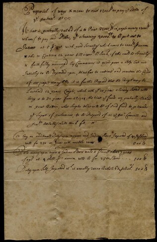
"Proposal of ways & means to raise 12000 [pounds] to pay the Debts of the . . .
. . . Government." List of various ways to raise money, including printing more money, and raising and creating taxes.
GLC03107.01157
1717/07/31
Livingston, Gilbert
to Robert Livingston re: end of the invasion of the Swedes
Gilbert writes that the King has disbanded troops and that the invasion of the Swedes is over. Docketed on address leaf.
GLC03107.01158
1741
Middleton, Conyers (fl. 1741)
The History of the Life of Marcus Tullius Cicero [2 vols.]
Two volumes, printed for the author. Collateral to GLC 747, John Adams to Rush, 1805 December 4, which attacks Hamilton as another Caesar while citing this life and "Tull's memoirs."
GLC05882
circa 1762-1767
Jefferson, Thomas (1743-1826)
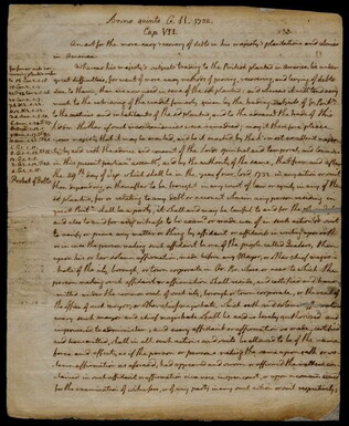
[Annotated manuscript copy of the 1732 acts of Parliament]
Jefferson's handwritten copy of a manuscript with notes entitled, "Anno quinto G[eorge]. II 1732. Cap. VII, An act for the more easy recovery of debts in his majesty's plantations and colonies in America." Establishes a law to coordinate debtors'...
GLC05886
1749
Schreibern, J.G. (fl. 1749)
Africa
One map entitled Africa, dated 1749. Contains the entire continent of Africa, as well as a small portion of the Middle East. The island of Madagascar is also included. The map and key are in German. Some sections are shaded indicating different...
GLC09862.01
1670
Child G., (fl. 1670)
The City of Loango from Dapper
One engraving entitled The City of Loango from Dapper dated 1670. Features a city view of Loango. In the foreground is groups of people working and traveling. The main feature of the image is the city which is labeled. The key lists locations...
GLC09862.05
1750
Kitchin, Thomas, (fl. 1750)
A Map of Part of the Rivers Faleme & Sanaga with the Countries of Bambuk & Tamba Awra drawn on the spot by M. Compagnon
One map entitled A Map of Part of the Rivers Faleme & Sanaga with the Countries of Bambuk & Tamba Awra drawn on the spot by M. Compagnon dated 1750. Features detailed map of the Faleme and Sanaga rivers and the cities and countries that the river...
GLC09862.06
1790
Walch, Jean, (fl. 1790)
Charte de L'Afrique
One map entitled A Map of Part of the Rivers Faleme & Sanaga with the Countries of Bambuk & Tamba Awra drawn on the spot by M. Compagnon dated 1750. Contains the entire continent of Africa, as well as a small portion of the Middle East. The island of...
GLC09862.07
1671
Montanus, (fl. 1670-1671)
View of Puerto Rico
An engraving entitled "Porto Rico" dated circa 1670. This engraving features a view of the port of Puerto Rico. The image contains twelve ships, some with people on them and a fort and buildings in the background. Originally published in an atlas by...
GLC09788
1759
Houston, Richard, 1721-1775
Major General James Wolfe
One engraving of James Wolfe during the Battle of Quebec. Attributes to the original engraving by Samuel Freeman. Noted that this print is engraved by R. Houston.
GLC08878.1034
Showing results 4771 - 4780