Meet the 2024 History Teachers of the Year!
1770-1780 circa
Frothingham, Richard, 1748-1819
[Framed silhouette of Richard Frothingham]
Small silhouette of Frothingham's head in profile in dark blue. Oval shaped gold gilt frame. Backing is no longer attached to frame.
GLC01450.065.02
20 July 1865
Ordway, K.G., fl. 1855-1865
[Congressional mourning ribbon]
Black ribbon with gold trim and fringes. There is a white rosette sewn on to the top with a gold sequence star and two sequence stars on the black part of the ribbon directle below the rosette. The entire ribbon is covered in black transparent silk...
GLC01423.01
1784 circa
Pico, Joshua, fl. 1760-1790
[Liquor merchant's trunk]
Belonged to Joshua Pico, a liquor merchant from Boston. Wooden chest with two handles, metal edges, and a lock on the lid. The key is missing so the lock is stuffed with paper to prevent locking. Interior has separated compartments for six large...
GLC01450.911
February 1782
Bauman, Sebastian, 1739-1803
Plan of the investment of York and Gloucester
Drafted at Washington's request, shortly after the battle of Yorktown, Virginia. Nebenzahl, Battle Plans of the American Revolution, 189, with references.
GLC01869
1779
Barres, Joseph Frederick Wallet des, 1722-1824
Plan of Fort Montgomery and Fort Clinton
From the Atlantic Neptune. Engraved and tinted map showing the Hudson River by Anthony's Nose with the Americans' chains across the river. Plate no. 19. (The map mistakenly calls the mountain "St. Anthony's Nose.") Nebenzahl, Battle Plans of the...
GLC01850
1784
Hills, John, fl. 1771-1796
Sketch of the position of the British forces at Elizabeth-Town Point
Original by John Hill. Oversize engraved map with hand coloring of troop positions. Engraved by Faden. Nebenzahl, Battle Plans of the American Revolution, 146.
GLC01858
1846
Preuss, Charles, fl. 1846
Topographical map of the road from Missouri to Oregon
Compiled by Charles Preuss, 1846, by command of the Senate. In Seven Sections. Scale 10 miles to the inch. Litho by E. Weber & Co., Baltimore.
GLC01873
1776
Brassier, William, fl. 1776
A survey of Lake Champlain, including Lake George, Crown Point... 1762
Includes (inset) "A particular plan of Lake George." The engraved map shows engagements between American and British forces on Lake Champlain. Not in Nebenzahl, Battle Plans of the American Revolution.
GLC01874
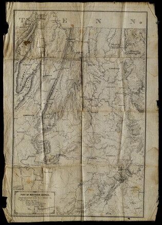
5 May 1864
Margedant, William C., 1835-?
Part of Northern Georgia
Printed "In the field" on cloth. Black and white lithograph depicts Northern Georgia. Compiled under the direction of William E. Merrill, Chief Topographical Engineer, Washington, D.C. Margedant was Captain and Superintendent of the Topographical...
GLC01740.06
2 May 1864
Merrill, W.E., 1837-1891
Map of Northern Georgia.
Created under the direction of Captain William E. Merrill, Chief Topographical Engineer. Lithographed map printed on paper squares mounted on cloth to facilitate folding. Contains handcoloring on roads and state borders. Based on Cherokee land maps...
GLC01740.02
Showing results 31 - 40