The Gettysburg College–Gilder Lehrman MA in American History: Apply now and join us for Fall 2024 courses
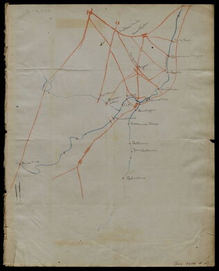
circa 1863-1864
Meigs, John R., fl. 1850-1864
[Maps of areas surrounding Staunton and Harrisonburg]
Hand-drawn maps in blue and red pencil of areas surrounding Staunton and Harrisonburg, Virginia.
GLC07059.17
[1863-1864]
Hand-drawn map in blue and red pencil, including towns of Newmarket, Hawkinsburg, and Woodstock.
Note on verso reads: "Field notes and maps found in pocket of J.R.M."
GLC07059.18
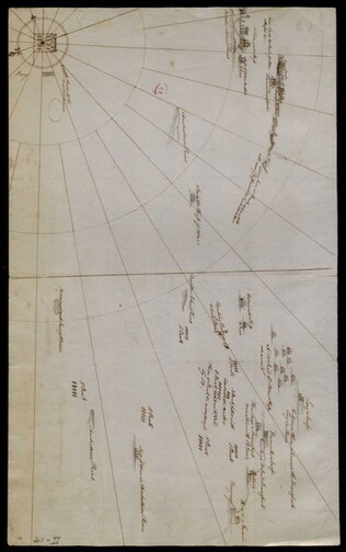
[Hand-drawn map]
Hand-drawn map in red and blue pencil.
GLC07059.19
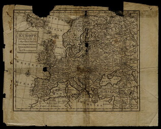
1758
Bennett, R., fl. 1758
Map of Europe describing its empires, kingdoms, and republics
GLC03107.05299
1856
Colton, Joseph Hutchins, 1800-1893
Map to illustrate Capt. Bonneville's adventures among the Rocky Mountains.
The map covers the western United States, with Washington, Oregon, California, Utah, New Mexico, Nebraska, Kansas, Texas, and Arkansas. Published in New York by George P. Putnam. Owned by John Moore (1826-1907), an army surgeon with the Utah...
GLC04194.01
circa July 1864
Stanley, Lucius T., 1844-1934
Battlefield Peach Tree Cr. Fought July 20 1864 Scale 4 in. pr. mi. from actual Survey by Topogs. of 1st Div 20 Corps
Notes houses, roads, military trails, locations of Union, including 1-3 Divisions of the 26th Corps and Confederate troops, lines of artillery, and barracks. Items are identifiable though the legend on the top of the map. Signed "Stanley fecit." Map...
GLC02710.35
[Union Civil War battlefield map of the Battle of Peachtree Creek]
Untitled draft of "Battlefield Peach Tree Cr. Fought July 20 1864 Scale 4 in. pr. mi. from actual Survey by Topogs. of 1st Div 20 Corps," found in GLC02710.35. Notes houses, Howel's Mill and Collier's Mill, a burned bridge, roads, and waterways...
GLC02710.36
circa May 1863
[Chancellorsville map showing Hooker, Jackson's attack, and site of the latter's death]
Shows Stonewall Jackson's route, his attack on the 11th Corps on 2 May 1863, and the "Place where Jackson was killed." Many annotations on reconnaissance, military activities, and places occupied by certain commanders, including Joseph Hooker. Shows...
GLC02710.37
circa 1864
Atlanta, and its rebel defences
Printed Civil War map from the Atlanta Campaign. Names major streets. The Fair Ground, Cemetery, the Locomotive House of the W & A Railroad, the Atlanta Steam Tannery, White Hall, and the headwaters of South River are indicated. The tracks for the...
GLC02710.38
circa 1818-1821
Gavit & Duthie, fl. 1840-1850
Map of the Frontiers of the Northern Colonies with the Boundary Line established Between them and the Indians at the Treaty held by S. Will Johnson at Ft. Stanwix in Novr. 1768.
This document is a map that shows the Colonies of New York, New Jersey, Maryland, Virginia, and the Ohio Valley Territory to the west of them. The map contains corrections and improvements from the Evans Map made by Guy Johnson, who was a British...
GLC05634.08
27 July 1841
Sarony & Co., 1854-1857
[Facsimile of map of New Netherlands using the names of Native American tribes to indicate location]
Printed on the bottom left corner is the signature of John Romeyn Brodhead, an agent of the State of New York hired to procure and transcribe documents in Europe. Signed by P.H. Loffelt, who copied this document for Brodhead in the Hague, and by J.C...
GLC05859.02
1861-1865
to Sarah Wood
Map of an unnamed town, with various houses identified.
GLC02176.42
Goss, Warren, fl. 1864-1880
Map of the prison
Map of the prison, with the locations of photographs # 1, 2, 4, 5, 6, 7 marked.
GLC06999.36
Map of the prison and surrounding areas.
GLC06999.37
1862
Abbot, Henry Larcom, 1831-1927
Campaign Maps Army of the Potomac, Map No. 1. Yorktown to Williamsburg [Manuscript map signed]
Title continues: "Prepared by Command of Maj. Gen. George B. Mc.Clellan U.S.A. Commd'g Army of the Potomac A.A. Humphreys Brig. Gen. and Chief of Top. Engr's." Accomplished on four pieces on joined wove paper. Photographed at the Coast Survey Office...
GLC04355.02
Campaign Maps Army of the Potomac, Map No. 1. Yorktown to Williamsburg
Title continues: "Prepared by Command of Maj. Gen. George B. Mc.Clellan U.S.A. Commanding Army of the Potomac Brig. Gen. A.A. Humphreys Chief of Top. Engrs Army of the Potomac." Engraved by W.H. Dougal. Map compiled by Abbot. Printed version of...
GLC04355.03
GLC04355.04
Campaign Map Army of the Potomac, Map No. 3. White House to Harrisons Landing
Title continues: "Prepared by Command of Maj. Gen. George B. Mc.Clellan U.S.A. Commd'g Army of the Potomac A.A. Humphreys Brig. Gen. and Chief of Top. Engr's." Map compiled by Abbot. Photographed at the Coast Survey Office. A very faint brown-line...
GLC04355.05
"Prepared by Command of Maj. Gen. George B. Mc.Clellan U.S.A. Commanding Army of the Potomac Brig. Gen. A.A. Humphreys Chief of Top. Engrs Army of the Potomac." Print engraved by W.H. Dougal. Map compiled by Abbot.
GLC04355.06
Campaign Maps Army of the Potomac, Map No. 2. Williamsburg to White House
Title continues: "Prepared by Command of Maj. Gen. George B. Mc.Clellan U.S.A. Commd'g Army of the Potomac A.A. Humphreys Brig. Gen. and Chief of Top. Engr's. Photographed at the Coast Survey Office. A faint brown-line print on four pieces of joined...
GLC04355.07
GLC04355.08
circa December 1862
Bush, George, fl. 1862
[Map of Fredericksburg]
A fairly complete and accurate map of the Union position at Fredericksburg. Shows federal positions, pontoon bridges, geographic features, roads and houses used as hospitals. The position held by Gibbon's Division is slightly exaggerated.
GLC03607.08
20 March 1862
Worret, Charles, 1819-?
[Manuscript map, Military Reconnaissance Dept. Va]
Title continues: "Major Genl. Wool Comdg. Drawn by Sergt. Worret & Compiled Under the Direction of Colonel T.J. Cram Chief Topl. Engr. Dept. Va." "Copy." Shows the Yorktown Peninsula and contains a description of the area in terms of its potential...
GLC04355.01
circa 1775-1776
[Battle plan for the siege of Boston Harbor]
Mapped battle plan for an American siege of Boston Harbor. Shows boats and some major geographic markers. For written plans see GLC02437.00231.
GLC02437.00232
10 June 1775
Montrésor, John, 1736-1799
A Map of the Province of New York with part of Pensylvania, and New England, from an actual survey by Captain Montrésor, Engineer, 1775
Includes insets of Connecticut River area and Lake Champlain area. Shows upper New York, Connecticut, Vermont. Framed to 92.7 x 113 cm. "P. Andreus, Sculpter" appears in lower right corner.
GLC03101.01
Showing results 3926 - 3950