Visit the new and improved Hamilton Education Program website
1794/05/14
Whittle, & Laurie, fl. 1759
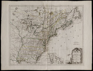
A new and general map of the middle dominion belonging to the United States...
The map shows part of the United States, from western New England to Michigan, and from Vermont to southern Virginia.
GLC04178
1864
Bacon & Company (San Francisco, Calif.)
Bacon's Large Print War Map Showing 50 Miles round Washington and Richmond
Shows major towns, waterways, and railroads. Concentric circles with intervals of ten miles each surround both Washington and Richmond. A red line shows General Ulysses S. Grant's route from Fredericksburg to Petersburg, Virginia, and a blue line...
GLC04175
1863/05/23
Winn, Charles A., fl. 1863
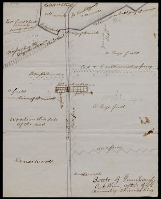
[Battle of Gum Swamp]
Shows the Confederate and Union lines, the locations of a Massachusetts brigade attack and other skirmishes, and the arrangement of fields, woods, roads, and fences. Captain Winn, of Company G in the 58th Pennsylvania Infantry, commanded the skirmish...
GLC04158
1826
Finley, Anthony, fl. 1826
A New American atlas... [fifteen copper-plate engraved maps]
Anthony Finley publisher and putative compiler. Folio volume. Includes maps of the United States ("Map of the United States Constructed," New York, Ohio, Missouri, and the different regions of America. Period hand-color.
GLC04173
1857
Wells, John G., 1821-1880
Well's new map of Missouri and Eastern Kansas
This is a fold out map contained within a book measuring 14.5 x 9 cm. When unfolded, the full title displayed on the map is "Well's New Railroad and Township Map of Missouri and Eastern Kansas from the latest Government Surveys." Contains a large...
GLC04174
1776
Pownall, Thomas, 1722-1805
A topographical description of such parts of North America... [with] Map
With "A Map of the Middle British Colonies in North America... 1776." Not in Nebenzahl, Battle Plans of the American Revolution, but 41 (Sayer & Bennett, American Military Pocket Atlas, no.3) is based on these maps.
GLC04176
1697
Livingston, Robert, 1654-1728
Drafft of this Countrey
One map depicting the path from Albany through Iroquois territory towards Lake Ontariot, onto St. Lawrence River to Montreal. On the left side is a key of geographical names. It is likely that the red crayon was drawn by the delegates and ink filled...
GLC03107.02046
[1768/11]
Indian Boundary Line as Settled by Sr. William & them in Nov[ember[ 1768
GLC03107.02166
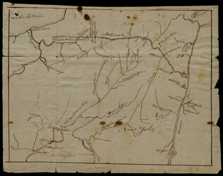
September 7, 1683
Livingston, Robert, 1663-1725
Settlements along the Susquehanna River
The map marks various settlements of the Senecas, Onondagas, and Cayugas along the Susquehanna River, and the length of travel between them. This map had borders drawn between Robert Livingston and three Iroquois delegates. The accompanying text...
GLC03107.01923
1846
J.H., Colton, & Co. (publishers), fl. 1856
Map of the United States, Mexico, and the West Indies, with parts adjoining
This document is a map of the United States, Mexico, and Caribbean territories belonging to George Cadwalader. Includes original holding case with "Cadwalader" inscription, which resembles a small book with a white binding ribbon. Map folds to 11.2 x...
GLC04577
Stephens, Ashbury L., 1843-?
[Manuscript Civil War map of General Sherman's Atlanta campaign]
Shows the route of Sherman's march from Chattanooga, Tennessee starting on 4 May 1864 and culminating with the siege of Atlanta on 8 September 1864. Drawn in black, red, yellow, and green ink on linen.
GLC04498.01
1776/03/12
Dury, Andrew, fl. 1775-1776
A Plan of Boston and its Environs... [siege of Boston]
Nebenzahl, Battle Plans of the American Revolution, 16.
GLC04410
1775/11/27
Sayer, Robert, 1725-1794
A Plan of the Battle on Bunkers Hill [Boston]
Nebenzahl, Battle Plans of the American Revolution, 28.
GLC04411
1786/08/15
A Map of the Whole Continent of America... [Wall Map on 4 sheets]
GLC04412.01
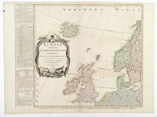
1787/01/01
Europe divided into its Empires, Kingdoms, States... [Wall Map on 4 sheets]
This map has an attractive depiction of Algiers and the Barbery states which is slightly larger than that for GLC# 4412.04 (Africa)
GLC04412.02
1787/01/06
Asia and its islands, according to D'Anville... [Wall Map on 4 sheets]
GLC04412.03
Africa with all its states, kingdoms... by S. Boulton [Wall Map on 4 sheets]
GLC04412.04
1861
Mitchell, Samuel P., fl. 1861
Sketch of the Country Occupied by the Federal & Confederate Armies on the 18th & 21st July 1861
Detailed map of the Battle of Manassas (Bull Run) showing roads, topographical features, troop positions, batteries, bridges, and railroads. Also has a legend of "Explanations." Pictures the battle field to the north of Manassas, with the Bull Run...
GLC05987.25
Baumgarten, J., fl. 1861
Seat of War Manassas and its Vicinity
Printed map detailing the battleground of 18 and 21 July 1861 at the Battle of First Manassas (Bull Run). Includes major roads and railroads, showing Washington D.C. on the right side. Contains descriptive text beneath the map. At the bottom is a...
GLC05987.26
Grant, M. B., fl. 1861
Map of the Seat of War
Compiled and drawn by M. B. Grant, lithographed by R. H. Howell, and published by T. A. Burke of the Morning News Office. Shows eastern Virginia (mostly Manassas and vicinity) and part of Maryland. A manuscript note on the bottom by a quartermaster...
GLC05987.22
1862
Manouvrier, Julius, 1816-1875
Map of the Present Seat of War in Missouri
Lithographic Confederate Civil War map on light blue paper. Illustrates the border area between Missouri and Kentucky. Manouvrier was a cartographer in New Orleans, Louisiana. His company was named J. Manouvrier & Co.
GLC05987.23
Plan of the Seat of War
Lithographic map of the Chesapeake Bay area and the border between Virginia and Maryland with an inset of Harper's Ferry, by J. Manouvrier & Co., a cartographer in New Orleans, Louisiana. Backed with cloth.
GLC05987.24
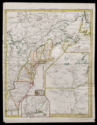
1755
Le Rouge, George L., fl. 1755
Canada et Louisiane [double page engraving with handcoloring]
Drawn by George Le Rouge, Engineer to the King. With hand-colored outlines. Double-page engraving showing the east coast of North America from New Foundland to Florida, with insets of Niagara Falls (small), New Orleans (medium) and upper Louisiana...
GLC05714
1777/06/17
Kitchin, Thomas, fl. 1750-1777
British dominions in America agreeable to the treaty of 1763...
With hand-colored outlines. Depicts the east coast of North America from New Foundland to Florida. Printed by Dury.
GLC05713
April 1862
[Field map made prior to the Civil War battles of Shiloh and Corinth]
This document is a manuscript map that shows major roads from Corinth to the Tennessee River, houses and their inhabitants, and occasionally their sympathies along the route. It also includes other topographical features. Drawn in pencil and brown...
GLC05759
June 1864
Bartelle, Charles V., fl. 1864
Sketch showing defences and channels of Charleston Harbor.
This document is a map of Charleston Harbor depicting the major waterways and various forts in the area, among these is Fort Sumter. On the map it states that the map has been, "Copied by direction of Rear Admiral J. A. Dahlgren." The water on the...
GLC05919
1863
Howell, R.H., fl. 1861-1863
Sea Coast of Georgia
Lithographed and published by Howell, cartographer unknown. Printed Civil War map showing the coastal area of Georgia from Florida to South Carolina. Marks railroads, canals, and major geographical points of interest. According the previous owner...
GLC05987.38
5 May 1862
Smith, Henry W., 1836-1869
[Manuscript Civil War map of the Battle of Williamsburg]
Shows the troop positions of forces under Union generals Philip Kearney and Joseph Hooker, as well as the Confederate line. Also shows the open field where the combatants met, Fort Magruder, and other structures. Smith is identified on the docket...
GLC06161
7 December 1862
Brooks, Alfred F., fl. 1862
[Manuscript Civil War map of the Battle of Murfreesboro]
Hand-colored map depicting Confederate and Union troop and artillery positions, and the location of a hospital. Brooks was the Acting Topographical Engineer, 2nd Brigade, 5th Division, 14 Army Corps.
GLC06162
Colton, Joseph Hutchins, 1800-1893
Colton's Plans Of U.S. Harbors Showing The Position & Vicinities Of The Most Important Fortifications On The Sea-Board And In The Interior. From U.S. Surveys and other authentic sources.
Printed and folded twenty one panel Civil War map marked "No. 5." Bound in a booklet listing major administration officials and generals on the inside cover, both Union and Confederate. Shows the Mississippi River from New Orleans to Cairo...
GLC06157.06
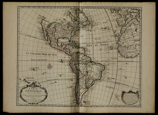
1722
De L'Isle, Guillaume, fl. 1718
Carte d'Amerique
Mercator projection including North and South America, with parts of Western Europe and Africa. Boundaries outlined in color. Shows North America from French perspective with English colonies restricted to the coast. Includes latitude and longitude...
GLC05238
1792
Ellicott, Andrew, fl. 1792
[Map of Washington, D.C.].
Engraved folding map removed from the "Columbian Magazine." Included with a letter from Thomas Jefferson to Charles W. Dumas (GLC07104.01).
GLC07104.02
1865
Sherman, William T. (William Tecumseh), 1820-1891
Military Map Showing the Marches of the United States Forces Under Command of Maj. Genl. W.T. Sherman, U.S.A. During the Years 1863, 1864, 1865
Black and white map ranging from Missouri to Maryland in the north and Louisiana to Georgia in the south. Sherman's routes are outlined in red, blue, green, yellow and brown. Compiled according to Sherman's order by Brevet Major W.L.B Jenney, and...
GLC07086.01
21 November 1863
West, Preston F., fl. 1863
No. 5 Map of Chattanooga and Vicinity
The title continues: "Compiled from Surveys and Information Under the Direction of Capt, W.E. Merrill U.S. Engrs. Chattanooga Nov 21st 1863." However, "Capt, W.E. Merrill U.S. Engrs" is crossed out and underneath is hand written: "Capt. Preston F...
GLC07086.02
Jenney, William Le Baron, 1832-1907
[Civil War map of Mississippi and Alabama]
Covers northern segments of the two states, showing towns, watercourses, railroads, and roads. Also shows Corinth and vicinity. The Tennessee River appears prominently, colored with a light blue paint wash. The map is painted and drawn on a coated...
GLC07086.03
circa 1861
Klosterman, H., fl. 1861
Map of the Seat of War in South Carolina
Shows the Atlantic coast from Savannah to Winyaw Bay, with Charleston featured prominently in the lower center. Indicates towns, roads, and some topographical features. Painted and drawn on a coated, fine weave "architect's" linen. Mostly black...
GLC07086.04
12 June 1862
Blanchard, C. D., fl. 1862
[Manuscript Civil War map of the battleground of the Battle of Seven Pines]
Shows roads, streams, and some troop positions. Drawn on a scale of 200 paces or 133-1/3 yards to an inch. The Battle of Seven Pines took place on 31 May 1862-1 June 1862. Blanchard served as Chief Quartermaster, 4th Corps. Mostly black & white...
GLC06061.01
circa 1719-1721
Senex, John, fl. 1719-1721
A map of Louisiana and of the river Mississippi by John Senex
Engraved map of North America from Chesapeake Bay to the Rio del Norte. English version of the first map to show Texas, earlier land routes, and details of gulf region and the Mississippi. Original outline coloring. Scale: 1 inch = approximately 22...
GLC06090
1810
Arrowsmith, Aaron, 1750-1823
A new map of Mexico and adjacent provinces [roll map on linen]
A New Map of Mexico and Adjacent Provinces Compiled from Original Documents.... London: Published 5th. October 1810, by A. Arrowsmith, 10 Soho Sque. Hydrographer to His Majesty, 1810. Wall map, mounted on linen, with wooden rollers at top and bottom...
GLC06091
1856 ca.
To the free men of the North [election] [large cloth-backed lithographed map]
Free Labor Party abolitionist map used during the 1856 presidential campaign, printed, with hand-coloring in red, black and green.
GLC06662
February 1865
Aveleen, E. J., fl. 1865
[Manuscript Civil War map of the Confederate defenses around Sea Island, South Carolina]
Shows defenses between Secessionville and Fort Pringle, and down towards Forts Mahan and Delafield on Folly Island. James Island also appears. Shows the obstacles facing the Union's approach to Charleston, South Carolina in early 1865, including...
GLC06380
4 July 1863
Howard, Richard L., fl. 1863
[Map of the front view of Vicksburg]
Howard, Chaplain of the 124th Illinois Infantry, depicts Vicksburg, Mississippi and the surrounding area in black and red ink. Illustrates the Mississippi and Yazoo Rivers, a cottonwood forest, the Vicksburg and Texas Railroad line (destroyed)...
GLC06382.03
25 February 1777
Faden, William, fl. 1750-1836
A Plan of Operations... in New York... [Battle of White Plains]
First state with original handcolor. With C. Sauthier. "A plan of the operations of the King's army under the command of General Sir William Howe, K. B. in New York and East New Jersey, against the American Forces commanded by General Washington...
GLC06465
1870? ca.
Porter, Fitz-John, 1822-1901
Maps accompanying the proceedings of...the case of Fitz-John Porter [Atlas]
23 maps of Second Bull Run.
GLC07422
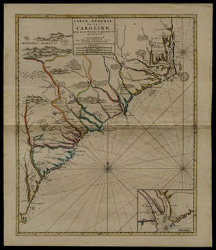
circa 1696
Sanson, Nicholas, 1600-1667
Carte generale de la Caroline dresse sur les memoirs le plus nouveaux
Map of North and South Carolina in an early period of settlement. Includes an inset of the area around Charleston, which locates plantations. This copy has a pencil note "1740" in margin, but no evidence for dating. In fact, this map remained...
GLC05236
12 March 1776
A Chart of Delaware Bay and River
Chart by Joshua Fisher. Depicts areas of Western New Jersey, Delaware, and Pennsylvania. There is extra shading on the shorelines of these states. Engraved by William Faden. Includes list of river pliots who subscribed to have it published. Slight...
GLC05237
1884
Royce, C. C., fl. 1884
Map of the former territorial limits of the Cherokee Nation of Indians
From the Fifth Annual Report printed by N. Peters. (Map printed by C.C. Royce.)
GLC05689
May 1862
[Confederate Civil War map of the Army of Mississippi camp at Corinth, Mississippi]
Manuscript map shows the lines of entrenchments and reinforcements, the Danville Road, cultivated land, camp roads, a cotton press, the O & M Railroad and C & M Railroad, and General William J. Hardee's headquarters. Map was blind stamped while...
GLC05668
1804/09/28
Krafft, C., fl. 1804
A View of Tripoli in Barbary
GLC07828
Map of the seat of war to accompany the American conflict
Removed from Harper's Weekly, Vol. 8, 1864 (GLC01733.06).
GLC01733.16
Showing results 101 - 150