The Gettysburg College–Gilder Lehrman MA in American History: Apply now and join us for Fall 2024 courses
1778/04/13
Faden, William, fl. 1750-1836
Battle of Brandywine...rebels were defeated, September 11th, 1777...
Nebenzahl, Battle Plans of the American Revolution, 126; British Library 123; Clemonts catalog 14, Snyder fig. 185.
GLC04313
1775
Montrésor, John, 1736-1799
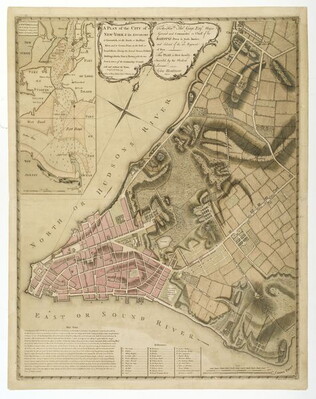
A Plan of the City of New York & its environs
Actual title: "A Plan of the City of New-York & its environs..." Shows Manhattan Island up to Greenwich Village. Hand colored.
GLC04315
1784
Plan of the Siege of Savannah...
Nebenzahl, Battle Plans of the American Revolution, 76.
GLC04316
1776/06/28
A Plan of the Attack on Fort Sulivan [Sullivan]... 28th of June 1776
Nebenzahl, Battle Plans of the American Revolution, 64.
GLC04317
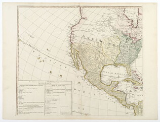
1796/01/01
Arrowsmith, Aaron, 1750-1823
A Map of the United States of North America
Handcolored. Each sheet is 66 cm high. The map shows the northwest territory outside the Union. A portion of Louisiana is included.
GLC04318
1776/10/19
A Plan of New York island, with part of Long Island... [second issue]
Nebenzahl, Battle Plans of the American Revolution, 107. Second issue dated a month later than GLC 3533 (first issue). This map shows British control of Manhattan.
GLC04177
1794/05/14
Whittle, & Laurie, fl. 1759
A new and general map of the middle dominion belonging to the United States...
The map shows part of the United States, from western New England to Michigan, and from Vermont to southern Virginia.
GLC04178
1864
Bacon & Company (San Francisco, Calif.)
Bacon's Large Print War Map Showing 50 Miles round Washington and Richmond
Shows major towns, waterways, and railroads. Concentric circles with intervals of ten miles each surround both Washington and Richmond. A red line shows General Ulysses S. Grant's route from Fredericksburg to Petersburg, Virginia, and a blue line...
GLC04175
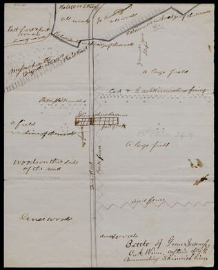
1863/05/23
Winn, Charles A., fl. 1863
[Battle of Gum Swamp]
Shows the Confederate and Union lines, the locations of a Massachusetts brigade attack and other skirmishes, and the arrangement of fields, woods, roads, and fences. Captain Winn, of Company G in the 58th Pennsylvania Infantry, commanded the skirmish...
GLC04158
1826
Finley, Anthony, fl. 1826
A New American atlas... [fifteen copper-plate engraved maps]
Anthony Finley publisher and putative compiler. Folio volume. Includes maps of the United States ("Map of the United States Constructed," New York, Ohio, Missouri, and the different regions of America. Period hand-color.
GLC04173
1857
Wells, John G., 1821-1880
Well's new map of Missouri and Eastern Kansas
This is a fold out map contained within a book measuring 14.5 x 9 cm. When unfolded, the full title displayed on the map is "Well's New Railroad and Township Map of Missouri and Eastern Kansas from the latest Government Surveys." Contains a large...
GLC04174
1776
Pownall, Thomas, 1722-1805
A topographical description of such parts of North America... [with] Map
With "A Map of the Middle British Colonies in North America... 1776." Not in Nebenzahl, Battle Plans of the American Revolution, but 41 (Sayer & Bennett, American Military Pocket Atlas, no.3) is based on these maps.
GLC04176
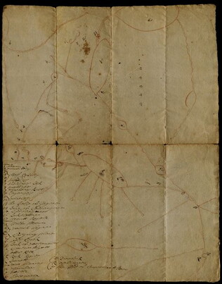
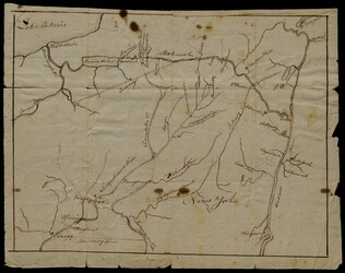
1697
Livingston, Robert, 1654-1728
Drafft of this Countrey
One map depicting the path from Albany through Iroquois territory towards Lake Ontariot, onto St. Lawrence River to Montreal. On the left side is a key of geographical names. It is likely that the red crayon was drawn by the delegates and ink filled...
GLC03107.02046
[1768/11]
Indian Boundary Line as Settled by Sr. William & them in Nov[ember[ 1768
GLC03107.02166
September 7, 1683
Livingston, Robert, 1663-1725
Settlements along the Susquehanna River
The map marks various settlements of the Senecas, Onondagas, and Cayugas along the Susquehanna River, and the length of travel between them. This map had borders drawn between Robert Livingston and three Iroquois delegates. The accompanying text...
GLC03107.01923
1846
J.H., Colton, & Co. (publishers), fl. 1856
Map of the United States, Mexico, and the West Indies, with parts adjoining
This document is a map of the United States, Mexico, and Caribbean territories belonging to George Cadwalader. Includes original holding case with "Cadwalader" inscription, which resembles a small book with a white binding ribbon. Map folds to 11.2 x...
GLC04577
Stephens, Ashbury L., 1843-?
[Manuscript Civil War map of General Sherman's Atlanta campaign]
Shows the route of Sherman's march from Chattanooga, Tennessee starting on 4 May 1864 and culminating with the siege of Atlanta on 8 September 1864. Drawn in black, red, yellow, and green ink on linen.
GLC04498.01
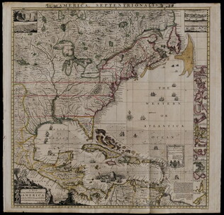
1733
Popple, Henry, fl. 1773
A Map of the British Empire in America... [index sheet, with 20 plates]
Large engraved map composed in sheets. Streeter Sale 676.
GLC04526
1776/03/12
Dury, Andrew, fl. 1775-1776
A Plan of Boston and its Environs... [siege of Boston]
Nebenzahl, Battle Plans of the American Revolution, 16.
GLC04410
1775/11/27
Sayer, Robert, 1725-1794
A Plan of the Battle on Bunkers Hill [Boston]
Nebenzahl, Battle Plans of the American Revolution, 28.
GLC04411
1786/08/15
A Map of the Whole Continent of America... [Wall Map on 4 sheets]
GLC04412.01
1787/01/01
Europe divided into its Empires, Kingdoms, States... [Wall Map on 4 sheets]
This map has an attractive depiction of Algiers and the Barbery states which is slightly larger than that for GLC# 4412.04 (Africa)
GLC04412.02
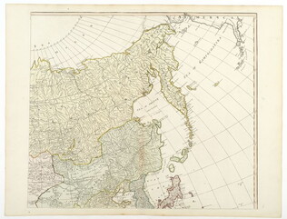
1787/01/06
Asia and its islands, according to D'Anville... [Wall Map on 4 sheets]
GLC04412.03
Africa with all its states, kingdoms... by S. Boulton [Wall Map on 4 sheets]
GLC04412.04
The Growth and Development of America in Maps
GLC09861
Showing results 301 - 325