The Gettysburg College–Gilder Lehrman MA in American History: Apply now and join us for Fall 2024 courses
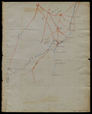
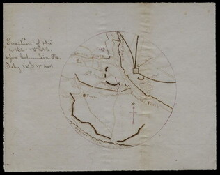
[1863-1864]
Meigs, John R. (fl. 1850-1864)
Hand-drawn map in blue and red pencil, including towns of Newmarket, Hawkinsburg, and Woodstock.
Note on verso reads: "Field notes and maps found in pocket of J.R.M."
GLC07059.18
Hand-drawn map in red and blue pencil.
GLC07059.19
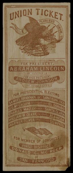
1864
Union Party (1864)
Union Ticket
Union ticket for the 1864 presidential election. Lists Abraham Lincoln for President and Andrew Johnson for Vice President. Lists electors for districts in California. Printed in orange. Printed on verso is an engraving of the ships, the Alabama...
GLC08498.01
circa 1867-1870
Farragut, David Glasgow, 1801-1870
[hat and epaulets in a tin box]
Tin box was crafted specifically to hold the hat and epaulets. It is 20.5 cm high, 45.5 cm long, and 20.75 cm in width. Inside, the hat lays on its side while two folding platforms hold the epaulets for easy storage. Below the epaulets are two spaces...
GLC08877
22 July 1864
Stephens, Asbury L. (b. 1843)
[Manuscript Civil War map of the position of the 2nd Division, 16th Army Corps in the Battle of Atlanta]
Shows the Confederate line, the positions of Union brigades, and a skirmish in the Battle of Atlanta. The legend indicates the positions at the beginning of the battle, the charging that occurred ("Rebel line charging") and the new line that was...
GLC04498.02
27 July 1864
Snell, J.P. (fl. 1864)
[Manuscript Civil War map of the Battle of Atlanta]
Presented by Snell to Asbury Stephens, "one of the participants this 23d. day of Sept. 1864, at Eastpoint, Ga." Shows where the 2nd Brigade crossed the railroad, moved into battle, position at the works, and its efforts to repulse the Confederates...
GLC04498.03
8 October 1864
[Manuscript Civil War map of the Plan of Rome, Floyd County, Georgia]
Shows the locations of fortifications, a steam boat landing, and troop positions. Made two days before General Hood's army skirmished with General Sherman's supply line near Rome, causing Sherman's forces to fortify themselves in the town. Colored...
GLC04498.04
[Manuscript Civil War map of the position of an army division at the Ogeecheee River in Georgia]
Shows the position of the 4th Division of the 15th Army Corps, the road to Savannah, the Confederate lines across the swamp. Also shows positions of various troops and General William T. Sherman's headquarters. Drawn in brown and pink ink a month...
GLC04498.05
February 1865
[Manuscript Civil War map of the siege of Columbia, South Carolina]
Circular map showing the position of the 4th Division of the 13th Army Corps, rivers, railroads, and roads around Columbia. General Sherman's siege was on 16-17 February 1865. Drawn in brown and pink ink.
GLC04498.06
circa January 1863
Jones, Joseph
[Map of fortifications]
GLC02739.159
Showing results 61 - 70