The Gettysburg College–Gilder Lehrman MA in American History: Apply now and join us for Fall 2024 courses
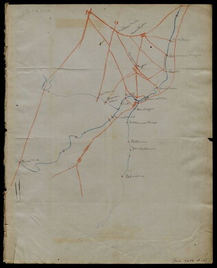
[1863-1864]
Meigs, John R., fl. 1850-1864
Hand-drawn map in blue and red pencil, including towns of Newmarket, Hawkinsburg, and Woodstock.
Note on verso reads: "Field notes and maps found in pocket of J.R.M."
GLC07059.18
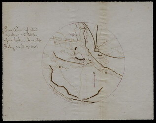
circa 1863-1864
[Hand-drawn map]
Hand-drawn map in red and blue pencil.
GLC07059.19
22 July 1864
Stephens, Ashbury L., 1843-?
[Manuscript Civil War map of the position of the 2nd Division, 16th Army Corps in the Battle of Atlanta]
Shows the Confederate line, the positions of Union brigades, and a skirmish in the Battle of Atlanta. The legend indicates the positions at the beginning of the battle, the charging that occurred ("Rebel line charging") and the new line that was...
GLC04498.02
27 July 1864
Snell, J.P., fl. 1864
[Manuscript Civil War map of the Battle of Atlanta]
Presented by Snell to Asbury Stephens, "one of the participants this 23d. day of Sept. 1864, at Eastpoint, Ga." Shows where the 2nd Brigade crossed the railroad, moved into battle, position at the works, and its efforts to repulse the Confederates...
GLC04498.03
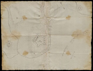
8 October 1864
[Manuscript Civil War map of the Plan of Rome, Floyd County, Georgia]
Shows the locations of fortifications, a steam boat landing, and troop positions. Made two days before General Hood's army skirmished with General Sherman's supply line near Rome, causing Sherman's forces to fortify themselves in the town. Colored...
GLC04498.04
[Manuscript Civil War map of the position of an army division at the Ogeecheee River in Georgia]
Shows the position of the 4th Division of the 15th Army Corps, the road to Savannah, the Confederate lines across the swamp. Also shows positions of various troops and General William T. Sherman's headquarters. Drawn in brown and pink ink a month...
GLC04498.05
February 1865
[Manuscript Civil War map of the siege of Columbia, South Carolina]
Circular map showing the position of the 4th Division of the 13th Army Corps, rivers, railroads, and roads around Columbia. General Sherman's siege was on 16-17 February 1865. Drawn in brown and pink ink.
GLC04498.06
1856
Colton, Joseph Hutchins, 1800-1893
Map to illustrate Capt. Bonneville's adventures among the Rocky Mountains.
The map covers the western United States, with Washington, Oregon, California, Utah, New Mexico, Nebraska, Kansas, Texas, and Arkansas. Published in New York by George P. Putnam. Owned by John Moore (1826-1907), an army surgeon with the Utah...
GLC04194.01
circa July 1864
Stanley, Lucius T., 1844-1934
Battlefield Peach Tree Cr. Fought July 20 1864 Scale 4 in. pr. mi. from actual Survey by Topogs. of 1st Div 20 Corps
Notes houses, roads, military trails, locations of Union, including 1-3 Divisions of the 26th Corps and Confederate troops, lines of artillery, and barracks. Items are identifiable though the legend on the top of the map. Signed "Stanley fecit." Map...
GLC02710.35
1862
Abbot, Henry Larcom, 1831-1927
Campaign Maps Army of the Potomac, Map No. 1. Yorktown to Williamsburg [Manuscript map signed]
Title continues: "Prepared by Command of Maj. Gen. George B. Mc.Clellan U.S.A. Commd'g Army of the Potomac A.A. Humphreys Brig. Gen. and Chief of Top. Engr's." Accomplished on four pieces on joined wove paper. Photographed at the Coast Survey Office...
GLC04355.02
Campaign Maps Army of the Potomac, Map No. 1. Yorktown to Williamsburg
Title continues: "Prepared by Command of Maj. Gen. George B. Mc.Clellan U.S.A. Commanding Army of the Potomac Brig. Gen. A.A. Humphreys Chief of Top. Engrs Army of the Potomac." Engraved by W.H. Dougal. Map compiled by Abbot. Printed version of...
GLC04355.03
GLC04355.04
Campaign Map Army of the Potomac, Map No. 3. White House to Harrisons Landing
Title continues: "Prepared by Command of Maj. Gen. George B. Mc.Clellan U.S.A. Commd'g Army of the Potomac A.A. Humphreys Brig. Gen. and Chief of Top. Engr's." Map compiled by Abbot. Photographed at the Coast Survey Office. A very faint brown-line...
GLC04355.05
"Prepared by Command of Maj. Gen. George B. Mc.Clellan U.S.A. Commanding Army of the Potomac Brig. Gen. A.A. Humphreys Chief of Top. Engrs Army of the Potomac." Print engraved by W.H. Dougal. Map compiled by Abbot.
GLC04355.06
Campaign Maps Army of the Potomac, Map No. 2. Williamsburg to White House
Title continues: "Prepared by Command of Maj. Gen. George B. Mc.Clellan U.S.A. Commd'g Army of the Potomac A.A. Humphreys Brig. Gen. and Chief of Top. Engr's. Photographed at the Coast Survey Office. A faint brown-line print on four pieces of joined...
GLC04355.07
GLC04355.08
circa December 1862
Bush, George, fl. 1862
[Map of Fredericksburg]
A fairly complete and accurate map of the Union position at Fredericksburg. Shows federal positions, pontoon bridges, geographic features, roads and houses used as hospitals. The position held by Gibbon's Division is slightly exaggerated.
GLC03607.08
20 March 1862
Worret, Charles, 1819-?
[Manuscript map, Military Reconnaissance Dept. Va]
Title continues: "Major Genl. Wool Comdg. Drawn by Sergt. Worret & Compiled Under the Direction of Colonel T.J. Cram Chief Topl. Engr. Dept. Va." "Copy." Shows the Yorktown Peninsula and contains a description of the area in terms of its potential...
GLC04355.01
20 May 1834
United States. Congress
Map of the Western Territory & c.
Large folding map of present-day Oklahoma with borders outlined in watercolour designating areas occupied by Native American tribes. Map was previously bound in back of the House Report found in 4132.01. Border lines are colored in blue, yellow...
GLC04132.02
1852
Horn, Hosea B., fl. 1852
Map to Illustrate Horn's Overland Guide to California and Oregon
Map originally attached to Horn's overland guide (housed with books, GLC 4152.01), from the U.S. Indian sub-agency, Council Bluffs, on the Missouri River, to the City of Sacramento, in California containing a table of distances, and showing all the...
GLC04152.02
circa 1782-1783
Bauman, Sebastian, 1739-1803
[Map of Forts Ontario and Oswego and surroundings]
Docketed as "A rough sketch of Oswego by Major Bauman." Shows Fort Ontario (captioned), Fort Oswego (uncaptioned) and surrounding features (possibly earthworks).
GLC02437.10667
9 December 1801
Gleason, John, fl. 1796-1811
[Copy of a survey map of land sold by Henry Knox to B. Joy of Boston]
Gleason and Robert Houston sign as surveyors. Depicts 16,340 acres of Waldo Patent land flanked by these notations: "Green, Waldo Heirs, Knox, Belfast, Northport, Lincolnville, and Bonapartte." A list of names is written in pencil within the area...
GLC02437.10341
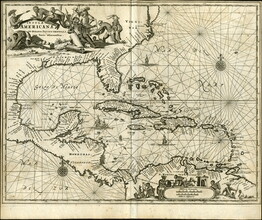
1671
Montanus, fl. 1670-1671
Insulae Americanae in Oceano Septentrionali, cum Terris adiacentibus [Map of the Americas]
A map entitled, "Insulae Americanae in Oceano Septentrionali, cum Terris adiacentibus" dated circa 1671. The map features Florida, the Gulf of Mexico, Cuba, the island of Espanolia which is modern day Haiti and Dominican Republic, Jamacia, Puerto...
GLC09789
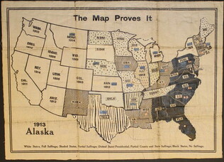
circa 1919
The Map Proves It [Women's suffrage map]
One map entitled "The Map Proves it" published circa 1919. This map illustrates the United States with different shading and colorizations of each state. The patterns and colors illustrate the status of the states in regards to women's suffrage...
GLC09773
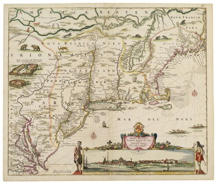
1682
Visscher, Nicholas, fl. 1682
Novi Belgi Novaeque Angliae [New Netherland and New England]
This map marks the culmination of Dutch surveys of their possessions in what became New York and New Jersey. Cartouche includes panorama of New York City (New Amsterdam). Engraved map, handcolored. See R. V. Tooley, The Mapping of America, p. 285 no...
GLC03582
Showing results 51 - 75