The Gettysburg College–Gilder Lehrman MA in American History: Apply now and join us for Fall 2024 courses
1884
Royce, C. C., fl. 1884
Map of the former territorial limits of the Cherokee Nation of Indians
From the Fifth Annual Report printed by N. Peters. (Map printed by C.C. Royce.)
GLC05689
May 1862
[Confederate Civil War map of the Army of Mississippi camp at Corinth, Mississippi]
Manuscript map shows the lines of entrenchments and reinforcements, the Danville Road, cultivated land, camp roads, a cotton press, the O & M Railroad and C & M Railroad, and General William J. Hardee's headquarters. Map was blind stamped while...
GLC05668
1804/09/28
Krafft, C., fl. 1804
A View of Tripoli in Barbary
GLC07828
circa 1863-1864
Meigs, John R., fl. 1850-1864
[Maps of areas surrounding Staunton and Harrisonburg]
Hand-drawn maps in blue and red pencil of areas surrounding Staunton and Harrisonburg, Virginia.
GLC07059.17
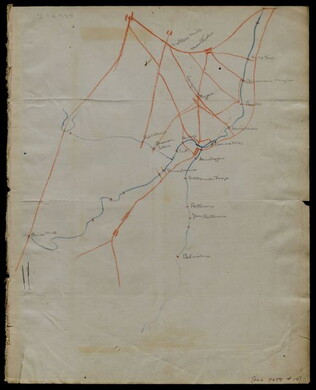
[1863-1864]
Hand-drawn map in blue and red pencil, including towns of Newmarket, Hawkinsburg, and Woodstock.
Note on verso reads: "Field notes and maps found in pocket of J.R.M."
GLC07059.18
[Hand-drawn map]
Hand-drawn map in red and blue pencil.
GLC07059.19
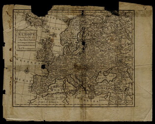
1758
Bennett, R., fl. 1758
Map of Europe describing its empires, kingdoms, and republics
GLC03107.05299
1856
Colton, Joseph Hutchins, 1800-1893
Map to illustrate Capt. Bonneville's adventures among the Rocky Mountains.
The map covers the western United States, with Washington, Oregon, California, Utah, New Mexico, Nebraska, Kansas, Texas, and Arkansas. Published in New York by George P. Putnam. Owned by John Moore (1826-1907), an army surgeon with the Utah...
GLC04194.01
circa July 1864
Stanley, Lucius T., 1844-1934
Battlefield Peach Tree Cr. Fought July 20 1864 Scale 4 in. pr. mi. from actual Survey by Topogs. of 1st Div 20 Corps
Notes houses, roads, military trails, locations of Union, including 1-3 Divisions of the 26th Corps and Confederate troops, lines of artillery, and barracks. Items are identifiable though the legend on the top of the map. Signed "Stanley fecit." Map...
GLC02710.35
[Union Civil War battlefield map of the Battle of Peachtree Creek]
Untitled draft of "Battlefield Peach Tree Cr. Fought July 20 1864 Scale 4 in. pr. mi. from actual Survey by Topogs. of 1st Div 20 Corps," found in GLC02710.35. Notes houses, Howel's Mill and Collier's Mill, a burned bridge, roads, and waterways...
GLC02710.36
Showing results 231 - 240