Visit the new and improved Hamilton Education Program website
1864
Richardson, W., fl. 1800-1810
[Battle map]
Hand-drawn battle map of the movements of the 23rd Army Corps during the siege of Atlanta, with positions of the Union and Confederate forces in Resaca, Marietta, and Atlanta.
GLC09321
circa 1585-1763
Lincoln & Edmands
Book of maps
The maps include the world, Asia, Europe, Africa, North America, South America, and New England States.
GLC03107.05320
circa 1852
[Slave Trade Map]
Depicting infamous African slave port of Lindi at the mouth of the Lindi River, terminus of East African Arab slave route.
GLC08363
February 1864
Jones, Joseph, fl. 1862-1865
[Fort of Sweetwater, Tennessee]
GLC02739.101
1861-1877
Works of Defense Surrounding Rienzi Tishomingo Co. Mississippi
One map depicting the Rienzi Tishomingo Co. in Mississippi.
GLC06728.142
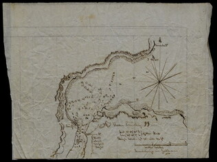
20 September 1864
Day, Albert A., 1840-?
Rough sketch of Richmond & Petersburg and surrounding works & railroads
Author is Captain Albert A. Day of Company K, 20th Michigan Infantry, 9th Corps. The map notes rail roads, General Ulysses S. Grant's supply train, Jerusalem Plank Road, Deep Bottom, Jones's Neck, Malvern Hill, Chickahominy River, the fortifications...
GLC02249.02
January 5, 1862
Gorsuch, Joseph B., 1834-1908
[Depiction of the battle of Chickasaw Bayou]
Drawn by Gorsuch, Captain of the 83rd Regiment Ohio Volunteer Infantry. Depicts the Yazoo River, fleet location, Confederate fortifications, Chickasaw Bayou, the Mississippi River, and the Vicksburg Texas Railroad, among other details. Indicates...
GLC00653.09.02
18 December 1943
Polgar, Lillian, fl. 1943
homemade map to Lillian and Frank's house
Hand drawn and colored map to Lillian and Frank Polgar's house. On the left of the drawing there are notes that say housewarming, and fifth wedding anniversary.
GLC09414.1568
30 April 1941
Japan Cabinet Printing Bureau
General Map of Greater East Asian Co-prosperity Sphere and Pacific Ocean
Map of territories included in the Japanese propaganda concept, the "Greater East Asian Co-prosperity Sphere." The concept promoted the cultural and economic unity of the region by a self-sufficient bloc of Asian nations led by the Japanese and free...
GLC09552.11
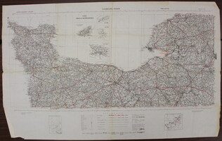
1941
War Office
[Map of French coast from Cherbourg to Rouen]
A first edition European road map published by the War Office in 1941, showing the French coast from Cherbourg to Rouen.
GLC09557.01
Showing results 201 - 210