Self-Paced Courses: Explore American history with top historians at your own time and pace!
no date
Unknown
Map from Stratford to Poughkeepsie
This printed map appears to be cut out of a larger book or atlas. Neither Stratford nor Poughkeepsie is on the map. Has slight water damage/staining.
GLC02437.08401
1881
United States. Congress.
Map showing Indian Reservations in the United States West of the 84th Meridian and Number of Indians belonging thereto, 1881.
One map related to the Indian reservations in the United States in the West dated 1881. Legends include "Indian Lands as established," "Lands, the Indian title to which is being extinguished," and "Lands to be established as Indian Lands." Also one...
GLC09679
circa 1940-1946
Cleartype Maps
[Cleartype General Map of the Pacific Ocean, Southeastern Asia, and Austrailia]
A map of the Pacific Ocean, Southeastern Asia and Austrailia. Copyright the American Map Company Inc. Originally published by Cleartype Maps. Contains Robert L. Stone's notes on where he traveled when he was deployed.
GLC09620.251
1900
Gannett, Henry (1846-1914)
Proportion of Foreign Born to Total Population of the United States at the Twelfth Census 1900.
One map containing the results of the of the twelfth census of the foreign immigrant population in the United States printed in 1900. Results were compiled by geographer Henry Gannett. Map shows that the largest foreign populations were in the...
GLC09668
1870
Population, United States, 1870
One map of the overrall population census in the United States date 1870. Map contains five quadrants analyzing different populations such as; "Density of Population," "Foreign Population," " Colored Populaion," "British American Population," and...
GLC09669
30 April 1941
Japan Cabinet Printing Bureau
General Map of Greater East Asian Co-prosperity Sphere and Pacific Ocean
Map of territories included in the Japanese propaganda concept, the "Greater East Asian Co-prosperity Sphere." The concept promoted the cultural and economic unity of the region by a self-sufficient bloc of Asian nations led by the Japanese and free...
GLC09552.11
1941
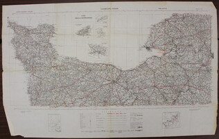
War Office
[Map of French coast from Cherbourg to Rouen]
A first edition European road map published by the War Office in 1941, showing the French coast from Cherbourg to Rouen.
GLC09557.01
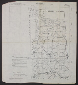
March 1944
War Department Corps of Engineers, U.S. Army
[Photo-map index]
A two-sided photo-map index of the English Channel. One side of the map shows Cherbourg, France, the English Channel, and Grande Rade. There is a grid over the map labled 1 to 29 on the y-axis and A to O on the x-axis. The reverse side of the map...
GLC09557.02
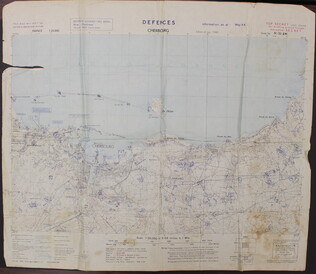
May 1944
Defences Cherbourg
A two-sided map of the defences of Cherbourg, France. The shows the map itself, while the back has a large ledgend. There is a tear in the upper left quadrant of the map.
GLC09557.03
U.S. Army
Defences Lessay
A two-sided map of the defences of Lessay, France. The front shows the map itself, while the back has a large ledgend.
GLC09557.04
Showing results 81 - 90