The Gettysburg College–Gilder Lehrman MA in American History: Apply now and join us for Fall 2024 courses
no date
Unknown
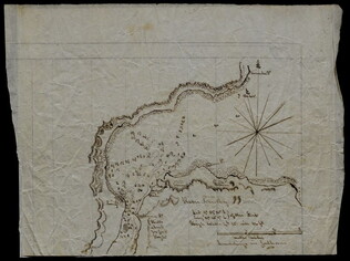
[Survey map of 329.5 acre tract]
Tract broken into three sections. Since this is part of the Duley family papers, the land was probably in Kentucky. Probably circa 1850-1900.
GLC06377.12
circa 1852
[Slave Trade Map]
Depicting infamous African slave port of Lindi at the mouth of the Lindi River, terminus of East African Arab slave route.
GLC08363
1852
Horn, Hosea B. (fl. 1852)
Map to Illustrate Horn's Overland Guide to California and Oregon
Map originally attached to Horn's overland guide (housed with books, GLC 4152.01), from the U.S. Indian sub-agency, Council Bluffs, on the Missouri River, to the City of Sacramento, in California containing a table of distances, and showing all the...
GLC04152.02
1846
Preuss, Charles, fl. 1846
Topographical map of the road from Missouri to Oregon
Compiled by Charles Preuss, 1846, by command of the Senate. In Seven Sections. Scale 10 miles to the inch. Litho by E. Weber & Co., Baltimore.
GLC01873
Mitchell, Augustus S., fl. 1846
Map of Texas, Oregon and California [pocket atlas]
Full title: A New Map of Texas, Oregon and California with the Regions Adjoining. Compiled from the Most Recent Authorities. First printing of this landmark map of the American West. Baughman, Kansas in Maps, p. 35. Graff 2841. Howes M685. Martin &...
GLC02130
Showing results 6 - 10