Visit the new and improved Hamilton Education Program website
30 March 1774
Flucker, Thomas, 1719-1783
[Map of land]
A drawn map of land, likely located in Maine, deeded to Francis Waldo from Thomas and Hannah Flucker. Shows lakes, rivers, and boundary lines. Date taken from docket.
GLC02437.10645
4 July 1781
Storers, Christian, fl. 1781
[Sketch of land]
Charles Miller signed the docket on 2 November 1801. A sketch of Christian Storers' surveyed land lying in "Waldowborough" [Waldoborough, Maine]. Includes written information regarding boundary lines and a drawn compass showing cardinal directions...
GLC02437.10646
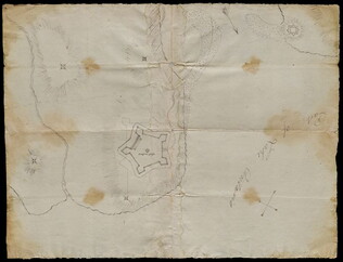
circa 1782-1783
Bauman, Sebastian, 1739-1803
[Map of Forts Ontario and Oswego and surroundings]
Docketed as "A rough sketch of Oswego by Major Bauman." Shows Fort Ontario (captioned), Fort Oswego (uncaptioned) and surrounding features (possibly earthworks).
GLC02437.10667
17 January 1777
Barres, Joseph Frederick Wallet des, 1722-1824
A sketch of the operations.... [Howe's occupation of New York]
One map entitled A sketch of the operations concerning Howe's occupation of New York dated January 17, 1777. From the Atlantic Neptune. The map depicts New York, roughly from Haverstraw Bay in the north, to Sandy Hook in the South. Land masses are...
GLC10031
1770
Rollos, George, fl. 1770
An Accurate Map of Africa Drawn from the Sieur Robert with Improvements
One map entitled An Accurate Map of Africa Drawn from the Sieur Robert with Improvements, dated 1770. Contains the entire continent of Africa, as well as a small portion of the Middle East. The island of Madagascar is also included. The map notes...
GLC09862.02
Showing results 51 - 55