The Gettysburg College–Gilder Lehrman MA in American History: Apply now and join us for Fall 2024 courses
9 November 1812
Winchester, Marcus (fl. 1812-)
Map of Ohio
Manuscript map of the Ohio river environs, extending north into Canada, west to F. Recovery, south to Kentucky, and east to Pennsylvania.
GLC06997.018
no date
Unknown
Map from Stratford to Poughkeepsie
This printed map appears to be cut out of a larger book or atlas. Neither Stratford nor Poughkeepsie is on the map. Has slight water damage/staining.
GLC02437.08401
[rudimentary map of John Jackson's estate]
backside contains figures
GLC03769.008
9 December 1801
Gleason, John (fl. 1796-1811)
[Copy of a survey map of land sold by Henry Knox to B. Joy of Boston]
Gleason and Robert Houston sign as surveyors. Depicts 16,340 acres of Waldo Patent land flanked by these notations: "Green, Waldo Heirs, Knox, Belfast, Northport, Lincolnville, and Bonapartte." A list of names is written in pencil within the area...
GLC02437.10341
23 July -6 August 1784
Galbraith, P. Bartrem (fl. 1784)
[Map of the Susquehanna River]
Drawn map of a portion of the Susquehanna River, with creeks, forts, and ferry landings noted. Also includes the distances to various points on the map. Noted as drawn above Canawago Falls, which is in Pennsylvania.
GLC02437.10583
1792
Pierpont, Joseph (fl. 1792)
[Map of land]
Map of the land by the Penobscot River. Water is drawn with blue watercolor ink. Shows the division of land into different plots.
GLC02437.10593
circa 1796-1806
A sketch of land surveyed by John Gleason. Cover 50,000 acres of land likely located in Maine. Shows a pond and various land marks in water colors and has a partially colored border.
GLC02437.10650
circa 1784-1806
A drawn map of lands near the Penobscot River in Maine. Land is noted as belonging to the heirs of Brigadier [General Samuel] Waldo. Lakes and rivers are noted in blue water color. Includes a drawn compass showing cardinal directions.
GLC02437.10652
circa 1790
Noted as a copy. Drawn sketch of a plan for the northwestern part of the Waldo Patent located in Maine. Depicts county lines and the northern and western boundaries of the Waldo Patent. Date was added later in pencil.
GLC02437.10666
1784
Hills, John, fl. 1771-1796
Sketch of the position of the British forces at Elizabeth-Town Point
Original by John Hill. Oversize engraved map with hand coloring of troop positions. Engraved by Faden. Nebenzahl, Battle Plans of the American Revolution, 146.
GLC01858
circa November 1813
Gwinnett, Button, 1735-1777
[Map of Button Gwinnett's estate]
Hand sketched map of Gwinnett's estate in Georgia of 1450 acres showing the bordering properties. Mentions neighboring properties of James Spalding and Mary Maxwell. Circa date from typed label originally accompanying the document upon acquisition.
GLC00658.02
1787
Tarleton, Banastre, 1754-1833
A History of the campaigns of 1780 and 1781, in the Southern Provinces
With Newberry Library bookplate and library stamp of the Newberry. Accompanied by William Eaton fold-out map (49 x 66 cm), showing Cornwallis' marches through Virginia and Maryland (while Jefferson was governor of Virginia).
GLC03667
Faden, William, fl. 1750-1836
Plan of the Siege of Savannah...
Nebenzahl, Battle Plans of the American Revolution, 76.
GLC04316
1796/01/01
Arrowsmith, Aaron, 1750-1823
A Map of the United States of North America
Handcolored. Each sheet is 66 cm high. The map shows the northwest territory outside the Union. A portion of Louisiana is included.
GLC04318
1794/05/14
Whittle, & Laurie, fl. 1759
A new and general map of the middle dominion belonging to the United States...
The map shows part of the United States, from western New England to Michigan, and from Vermont to southern Virginia.
GLC04178
1786/08/15
Sayer, Robert, 1725-1794
A Map of the Whole Continent of America... [Wall Map on 4 sheets]
GLC04412.01
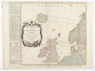
1787/01/01
Europe divided into its Empires, Kingdoms, States... [Wall Map on 4 sheets]
This map has an attractive depiction of Algiers and the Barbery states which is slightly larger than that for GLC# 4412.04 (Africa)
GLC04412.02
1787/01/06
Asia and its islands, according to D'Anville... [Wall Map on 4 sheets]
GLC04412.03
Africa with all its states, kingdoms... by S. Boulton [Wall Map on 4 sheets]
GLC04412.04
1810
A Map of Africa, From the best Authorities
One map entitled A Map of Africa, From the best Authorities, dated 1810. Contains the entire continent of Africa, as well as a small portion of the Middle East. The island of Madagascar is also included. The map notes many coastal cities, as well as...
GLC09862.03
Ellicott, Andrew, fl. 1792
[Map of Washington, D.C.].
Engraved folding map removed from the "Columbian Magazine." Included with a letter from Thomas Jefferson to Charles W. Dumas (GLC07104.01).
GLC07104.02
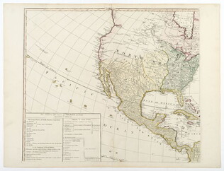
A new map of Mexico and adjacent provinces [roll map on linen]
A New Map of Mexico and Adjacent Provinces Compiled from Original Documents.... London: Published 5th. October 1810, by A. Arrowsmith, 10 Soho Sque. Hydrographer to His Majesty, 1810. Wall map, mounted on linen, with wooden rollers at top and bottom...
GLC06091
1804/09/28
Krafft, C., fl. 1804
A View of Tripoli in Barbary
GLC07828
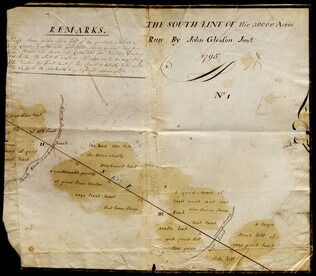
1795
Gleason, John, fl. 1796-1811
Map of surveyed land possibly located in Maine. Titled, "THE SOUTH LINE OF the 50000 Acres Run By John Gleason Junr 1795 No 1." Covers three miles and a half of land and includes notes on the quality of land. Document is partially printed with...
GLC02437.10598
Showing results 1 - 24