The Gettysburg College–Gilder Lehrman MA in American History: Apply now and join us for Fall 2024 courses
circa 1852
[Slave Trade Map]
Depicting infamous African slave port of Lindi at the mouth of the Lindi River, terminus of East African Arab slave route.
GLC08363
circa August 1861
Paris, George, fl. 1861
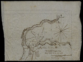
[Depicts the First Battle of Bull Run, or Manassas Plains, fought 21 July 1861]
Sketched in pencil and ink, with a later note describing Paris as a Mississippi soldier. Includes locations, camps, and positioning of troops. Inscribed on verso to George's mother Mary C. Paris.
GLC08432
9 November 1812
Winchester, Marcus (fl. 1812-)
Map of Ohio
Manuscript map of the Ohio river environs, extending north into Canada, west to F. Recovery, south to Kentucky, and east to Pennsylvania.
GLC06997.018
[1863-1864]
Meigs, John R. (fl. 1850-1864)
Hand-drawn maps in blue and red pencil of areas surrounding Staunton and Harrisonburg, Va.
GLC07059.17
Hand-drawn map in blue and red pencil, including towns of Newmarket, Hawkinsburg, and Woodstock.
Note on verso reads: "Field notes and maps found in pocket of J.R.M."
GLC07059.18
Showing results 21 - 25