Meet the 2024 History Teachers of the Year!
1873/03/04 ca.
Grant, Ulysses S. (Ulysses Simpson), 1822-1885
Ulysses S. Grant / President of the United States
Possibly an inaugural medal. Sculpted by W. & C. Harris. Paint is slightly worn and there are glue remnants on verso.
GLC02781.02
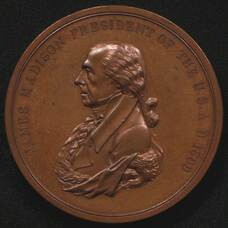
1809
Reich, John, fl. 1809
[James Madison Indian peace medal]
Medal features James Madison's profile on front and the words "James Madison President of the U.S. A.D. 1809." Designer is unknown. Verso features two hands shaking, a tomahawk crossed with a pipe, and the words, "Peace and Friendship," designed by...
GLC02767.02
1817 circa
Furst, Moritz, 1782-1840
[James Monroe Indian peace medal]
Indian peace medal with James Monroe's profile on front, with the words "James Monroe President of the U.S. A.D. 1817," designed by Moritz Furst. Verso features two hands shaking, a tomahawk crossed with a pipe, and the words, "Peace and Friendship,"...
GLC02768.02
1829 circa
[Andrew Jackson Indian peace medal]
Front of medal features profile of Andrew Jackson and the words "Andrew Jackson President of the United States. A.D. 1829," most likely designed by Moritz Furst. Verso features two hands shaking, a tomahawk crossed with a pipe, and the words, "Peace...
GLC02772.02
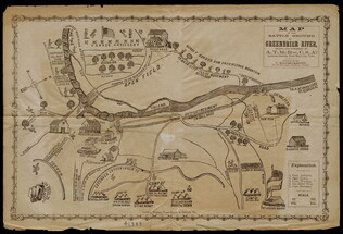
1861
McRae, A.T., fl. 1861-1862
Map of the Battle Ground of Greenbrier River
Wood and copper engraving of a battle in the Cheat Mountain Campaign, Robert E. Lee's first field command of the Civil War. This document is of Confederate origin and shows Camp Bartow, the Confederate position, in great detail, marking buildings...
GLC02875
circa 1864
Gilmer, Jeremy Francis, 1818-1883
Map of the vicinity of Petersburg
This document is a black and white, printed map depicting towns, rivers and creeks, rail lines, forested areas, and land segments divided by ownership surrounding Petersburg, Virginia. The map is extremely detailed, and includes names associated...
GLC02876
1864
Map of the Vicinity of Richmond, and Part of the Pennisula
Rare lithographic Confederate map "from surveys made by order of Major General J.F. Gilmer Chief Engineer C.S.A.," the cartographer is unknown. Shows Richmond and its environs in great detail, including roads, rivers, railroads, and towns. Probably...
GLC02877
1853
Bache, Alexander Dallas, 1806-1867
Galveston entrance, Texas, from a trigonometrical survey under the direction of A.D. Bache superintendant of the survery of the coast of the United States
Map of the Galveston entrance in Texas from 1853. Sailing directions written on righthand side of document, including information about tides. Harbor shown is the Gulf of Mexico. Includes compass. Scale noted on bottom. Triangulation by R.H...
GLC02941
1887
Johnson, A.J., fl. 1887
County map of the state of Texas
County map of Texas from 1887. Colored in pink and green. Includes a smaller map of the "plan of Galveston and vicinity." Page numbers on top of map are 64 and 65. Published by Wm Bradley & Bros.
GLC02942
Bachmann, John, fl. 1849-1885
Bird's-eye View of North and South Carolina and Part of Georgia
From the series: Panorama of the Seat of War. Locations of cities, towns, and military posts are identified as well as locations of naval ships. "Drawn from nature and lithographed by John Bachmann." Includes a key stating the distances between...
GLC03525
Showing results 81 - 90