The Gettysburg College–Gilder Lehrman MA in American History: Apply now and join us for Fall 2024 courses
1864
Unknown
[Pin with two American flags]
Stick pin with black knob at top. Attached to pin are two small cloth American flags and two ribbon tassels. Meant for the 1864 presidential election.
GLC05125.02
8 January 1777
[Map of roads in the vicinity of Morristown, New Jersey]
Indicates roads, some natural features, landmarks ("court house," "Whites Tavern Genl Lees," bridge, landing, etc.), outlying towns, and distance between points on the map. Indicates the location of towns surrounding Morristown. Notes the position...
GLC02437.09543
no date
Map from Stratford to Poughkeepsie
This printed map appears to be cut out of a larger book or atlas. Neither Stratford nor Poughkeepsie is on the map. Has slight water damage/staining.
GLC02437.08401
n.d.
[Canceled Stamps]
Miscellaneous canceled three-cent stamps. There are eight stamps.
GLC03523.10.229
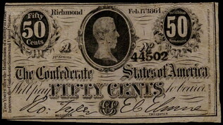
17 February 1864
Archer & Halpin (fl. 1864)
[Confederate States of America fifty cents paper currency note]
Signed in facsimile by Robert Tyler, as register and E.C. Elmore as the Treasurer of the Confederate States of America. No. 44502, engraved by Archer & Halpin, Richmond, Virginia.
GLC03501.02
14 October 1907
Oakes, George
to C. Bert Padon
Leather postcard with the phrase "Friends are like mellons shall I tell you why? To find one good, you must a hundred try." There are numerous names burned into the leather card.
GLC03136.106
5 June 1934
The James Millikin University Thirty-first Annual Commencement of Decatur College and Industrial School
Comments found next to the name of Charlotte Oakes "Gold Delta Honor-Magna Cum Laude Kappa Key"
GLC03136.116
circa 1861-1865
[Epaulet of John B. Moore]
Shoulder epaulets from Moore's dress uniform. The letter "M" appears, possibly accompanied by a missing "S" for "medical staff," accompanied by the other epaulet in GLC04196.13. These accoutrements appear in GLC 4196.01, Moore's photograph in dress...
GLC04196.12
Shoulder epaulets from Moore's dress uniform. The letter "S" appears, possibly accompanied by a missing "M" for "medical staff," accompanied by the other epaulet in GLC04196.12. These accoutrements appear in GLC 4196.01, Moore's photograph in dress...
GLC04196.13
1865
Goddard, Dighton (1822-1910)
Red wood heart of Dighton Goddard
Small, carved wooden heart painted red with writings in pencil, "Appomattox April 9th, 1865."
GLC03608.02
Wooden heart of Dighton Goddard
Small unpainted wooden carved heart with writing in pencil, "Lee surr. at App., Apr. 9, a time of rejoy and shouting."
GLC03608.03
[rudimentary map of John Jackson's estate]
backside contains figures
GLC03769.008
31 January 1759
letter seal, separated
for William Denny
GLC03769.033.01
Map of St. Augustine Harbor and Port
Map of St. Augustine Harbor and Port. San Sebastian River, North River, Matanzas River are pictured. Labels written in blue pen. Lighthouse Anastasia is labeled and drawn. Writing on verso specifies title of map.
GLC03974.40
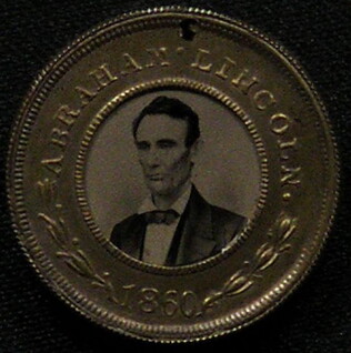
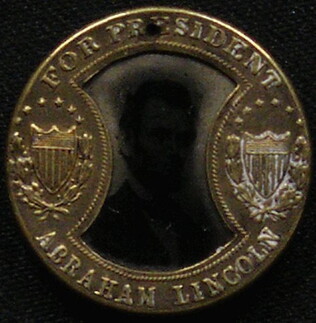
1860
[Republican campaign token for 1860 election]
With photographs of Abraham Lincoln and Hannibal Hamlin, on opposing sides. Gold border. Punched with hole at top.
GLC04102.02
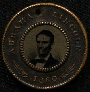
With photographs of Abraham Lincoln and Hannibal Hamlin, on opposing sides. Stamped with their names and the year. Gold border. Punched with hole at top.
GLC04102.03
GLC04102.04
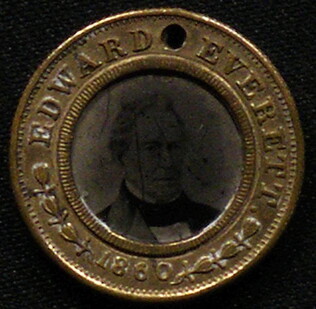
[Bell/Everett campaign token for 1860 election]
With photographs of Edward Everett and John Bell, on opposing sides. Stamped with their names and the year. Gold border. Punched with hole at top. Bell and Everett ran on the Constitutional Union ticket.
GLC04102.05
[Democratic campaign token for 1860 election]
With photographs of Stephen A. Douglas and Herschel V. Johnson, on opposing sides. Stamped with their names and the year. Gold border. Punched with hole at top. Douglas and Johnson ran on the Northern Democratic ticket.
GLC04102.06
[Republican campaign token for 1864 election]
With photographs of Abraham Lincoln and Andrew Johnson, one of each side. Stamped with their names and "for President," "for Vice-President." Gold border. Punched with hole at top.
GLC04102.07
1852
Horn, Hosea B. (fl. 1852)
Map to Illustrate Horn's Overland Guide to California and Oregon
Map originally attached to Horn's overland guide (housed with books, GLC 4152.01), from the U.S. Indian sub-agency, Council Bluffs, on the Missouri River, to the City of Sacramento, in California containing a table of distances, and showing all the...
GLC04152.02
1862-1863
Baker, T. Otis (fl. 1862-1863)
Calling Card
A calling card for "Mr. & Mrs. T. Otis Baker"
GLC03134.03
ca 1870-1879
[Postal card]
Blank postal card from Decatur Novelty works, Faries & Oakes, Boiler Makers and Machinists, Decautr, Ill.
GLC03136.086
1873
Peddecord, J. J.
[Wedding invitation]
GLC03136.095
1917
[Japanese 1917 calendar]
GLC03136.102
4 July 1866
Union League of Philadelphia
[Commemoration card of the Union League of Philadelphia, including information regarding a 4 July celebration]
Printed by King & Baird. One side of this card depicts the Union League. A print of a cannon and other weapons, an eagle, and three American flags are included on verso. Surrounding the image, text states "Union League of Philadelphia. Salute The...
GLC02608.03
1861-1877
God Be Merciful Unto Us
a psalm in a coaster size book
GLC02618.093
[pocketbook]
bound in blue leather. Contains paper and cloth.
GLC02750.478
15 March 1867
For Emma (A Calling Card)
Other side reads: Remember thy creator?
GLC02751.49
17 August 1900
unkown
Upper Silesia Plebiscite Area
Shows area of developed mineral resources, including coal bearing area. Also includes railways and district boundaries. Red line for final British proposal, Blue for French, and Green for League of Nations lines.
GLC02766.003
1831
Oberschlesien in Jahre [German]
Includes former and current boundaries.
GLC02766.005
Oberschlesien in der Gegenwart [German]
Upper Selesia.
GLC02766.006
Karte Von Schlesien [German]
Map of Selesia.
GLC02766.007
1871 - 1910
Bevolkerungsbewegung 1871 - 1910 [German]
Population Growth.
GLC02766.008
Upper-Silesian Plebiscite-Area
Final Results of the Plebiscite shown by districts.
GLC02766.009
Oberschlesien Deutche Zeit um 1350 [German]
Different regions in Silesia.
GLC02766.010
Oberschlesien [German]
From the Germanic up toward the end of of the Slavic Time in Silesia
GLC02766.012
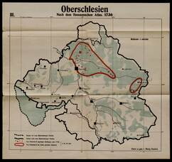
1730
Guckel, Marg (fl. 1730-)
Nach dem Homannschen Atlas 1730
GLC02766.013
1804
Bevolkerungsdichte von Oberschledien [German]
Population Density of Silesia.
GLC02766.014
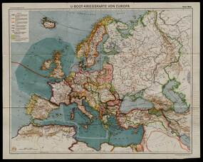
Flemming, Carl (fl. 1919-)
U-Boot-Kriegskate Von Europa [German]
U-Boat War Map
GLC02766.015
Map of Middle East
Includes railways and British Administration borders.
GLC02766.016
9 December 1801
Gleason, John (fl. 1796-1811)
[Copy of a survey map of land sold by Henry Knox to B. Joy of Boston]
Gleason and Robert Houston sign as surveyors. Depicts 16,340 acres of Waldo Patent land flanked by these notations: "Green, Waldo Heirs, Knox, Belfast, Northport, Lincolnville, and Bonapartte." A list of names is written in pencil within the area...
GLC02437.10341
23 July -6 August 1784
Galbraith, P. Bartrem (fl. 1784)
[Map of the Susquehanna River]
Drawn map of a portion of the Susquehanna River, with creeks, forts, and ferry landings noted. Also includes the distances to various points on the map. Noted as drawn above Canawago Falls, which is in Pennsylvania.
GLC02437.10583
1792
Pierpont, Joseph (fl. 1792)
[Map of land]
Map of the land by the Penobscot River. Water is drawn with blue watercolor ink. Shows the division of land into different plots.
GLC02437.10593
circa 1782
Erskine, Robert (1735-1780)
[Map of South Carolina]
A manuscript copy of a printed map of a portion of South Carolina. Shows lakes, rivers, streams, forest, towns, counties, and possibly roads. Noted, "Part of SOUTH CAROLINA copied by R. Erskine F. R. S. from A Map published in London 1771." Docket...
GLC02437.10611
30 March 1774
Flucker, Thomas (1719-1783)
A drawn map of land, likely located in Maine, deeded to Francis Waldo from Thomas and Hannah Flucker. Shows lakes, rivers, and boundary lines. Date taken from docket.
GLC02437.10645
4 July 1781
Storers, Christain (fl. 1781)
[Sketch of land]
Charles Miller signed the docket on 2 November 1801. A sketch of Christian Storers' surveyed land lying in "Waldowborough" [Waldoborough, Maine]. Includes written information regarding boundary lines and a drawn compass showing cardinal directions...
GLC02437.10646
circa 1796-1806
A sketch of land surveyed by John Gleason. Cover 50,000 acres of land likely located in Maine. Shows a pond and various land marks in water colors and has a partially colored border.
GLC02437.10650
circa 1784-1806
A drawn map of lands near the Penobscot River in Maine. Land is noted as belonging to the heirs of Brigadier [General Samuel] Waldo. Lakes and rivers are noted in blue water color. Includes a drawn compass showing cardinal directions.
GLC02437.10652
circa 1790
Noted as a copy. Drawn sketch of a plan for the northwestern part of the Waldo Patent located in Maine. Depicts county lines and the northern and western boundaries of the Waldo Patent. Date was added later in pencil.
GLC02437.10666
Showing results 151 - 200