The Gettysburg College–Gilder Lehrman MA in American History: Apply now and join us for Fall 2024 courses
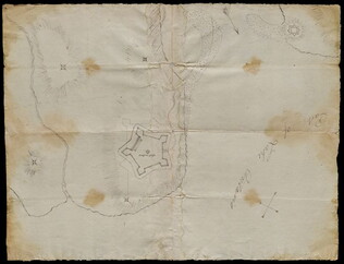
30 March 1774
Flucker, Thomas (1719-1783)
[Map of land]
A drawn map of land, likely located in Maine, deeded to Francis Waldo from Thomas and Hannah Flucker. Shows lakes, rivers, and boundary lines. Date taken from docket.
GLC02437.10645
4 July 1781
Storers, Christain (fl. 1781)
[Sketch of land]
Charles Miller signed the docket on 2 November 1801. A sketch of Christian Storers' surveyed land lying in "Waldowborough" [Waldoborough, Maine]. Includes written information regarding boundary lines and a drawn compass showing cardinal directions...
GLC02437.10646
circa 1796-1806
Gleason, John (fl. 1796-1811)
A sketch of land surveyed by John Gleason. Cover 50,000 acres of land likely located in Maine. Shows a pond and various land marks in water colors and has a partially colored border.
GLC02437.10650
circa 1784-1806
Unknown
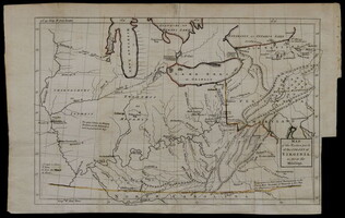
A drawn map of lands near the Penobscot River in Maine. Land is noted as belonging to the heirs of Brigadier [General Samuel] Waldo. Lakes and rivers are noted in blue water color. Includes a drawn compass showing cardinal directions.
GLC02437.10652
circa 1790
Noted as a copy. Drawn sketch of a plan for the northwestern part of the Waldo Patent located in Maine. Depicts county lines and the northern and western boundaries of the Waldo Patent. Date was added later in pencil.
GLC02437.10666
circa 1782-1783
Bauman, Sebastian (1739-1803)
[Map of Forts Ontario and Oswego and surroundings]
Docketed as "A rough sketch of Oswego by Major Bauman." Shows Fort Ontario (captioned), Fort Oswego (uncaptioned) and surrounding features (possibly earthworks).
GLC02437.10667
1865
General Benham's winter camp near Poplar Grove Church, Va., with photo of troops
Printed map, "Winter Camp, Detachment 50th N.Y.V. Engineers" Brevet Colonel I. Spalding Commanding, near Poplar Church, Virginia, Army of the Potomac, 1865. Has been partially hand colored. An original albumen photograph of soldiers with musical...
GLC00919.26
February 1782
Bauman, Sebastian, 1739-1803
Plan of the investment of York and Gloucester
Drafted at Washington's request, shortly after the battle of Yorktown, Virginia. Nebenzahl, Battle Plans of the American Revolution, 189, with references.
GLC01869
1779
Barres, Joseph Frederick Wallet des, 1722-1824
Plan of Fort Montgomery and Fort Clinton
From the Atlantic Neptune. Engraved and tinted map showing the Hudson River by Anthony's Nose with the Americans' chains across the river. Plate no. 19. (The map mistakenly calls the mountain "St. Anthony's Nose.") Nebenzahl, Battle Plans of the...
GLC01850
1784
Hills, John, fl. 1771-1796
Sketch of the position of the British forces at Elizabeth-Town Point
Original by John Hill. Oversize engraved map with hand coloring of troop positions. Engraved by Faden. Nebenzahl, Battle Plans of the American Revolution, 146.
GLC01858
1846
Preuss, Charles, fl. 1846
Topographical map of the road from Missouri to Oregon
Compiled by Charles Preuss, 1846, by command of the Senate. In Seven Sections. Scale 10 miles to the inch. Litho by E. Weber & Co., Baltimore.
GLC01873
1776
Brassier, William, fl. 1776
A survey of Lake Champlain, including Lake George, Crown Point... 1762
Includes (inset) "A particular plan of Lake George." The engraved map shows engagements between American and British forces on Lake Champlain. Not in Nebenzahl, Battle Plans of the American Revolution.
GLC01874
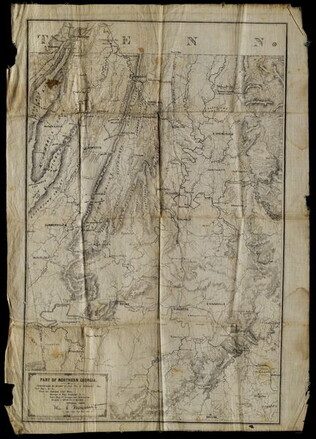
5 May 1864
Margedant, William C., 1835-?
Part of Northern Georgia
Printed "In the field" on cloth. Black and white lithograph depicts Northern Georgia. Compiled under the direction of William E. Merrill, Chief Topographical Engineer, Washington, D.C. Margedant was Captain and Superintendent of the Topographical...
GLC01740.06
2 May 1864
Merrill, W.E., 1837-1891
Map of Northern Georgia.
Created under the direction of Captain William E. Merrill, Chief Topographical Engineer. Lithographed map printed on paper squares mounted on cloth to facilitate folding. Contains handcoloring on roads and state borders. Based on Cherokee land maps...
GLC01740.02
1862
Nicholson, Walter L., ?-1895
Map of Eastern Virginia compiled from the best authorities, and printed at the Coast Survey Office.
Printed by the Coast Survey Office, compiled by Nicholson, and lithographed by Charles G. Krebs. Depicts eastern Virginia, Maryland and Delaware with portions of Pennsylvania, New Jersey, and North Carolina. Shows rail lines, rivers, and other...
GLC01740.03
1861
Colton, Joseph Hutchins, 1800-1893
Colton's new topographical map of the eastern portion of the State of North Carolina with part of Virginia and South Carolina, from the latest & best authorities.
Printed by Lang & Laing. Lithographed map with some hand-colored areas. Depicts eastern coastline of North Carolina with Atlantic Ocean and neighbone of North Carolina with Atlantic Ocean and neighboring states. According to a previous note, this...
GLC01740.04
15 November 1864-21 December 1864
Harris, Rodney E., fl. 1862-1865
Maps Showing the Campaign of the 20th Corps from Atlanta to Savannah with the Dates
Disbound booklet of ten chronological watercolor maps documenting the towns and cities General William T. Sherman passed through on his march to the sea, from Atlanta to Savannah, Georgia. At the end is a large manuscript account of the march...
GLC01888
1 November 1776
Hawkes, W., fl. 1776
The Country twenty-five miles round New York
Irregular shaped paper. Engraving with letterpress chronological table of events from 1773-Oct. 1776, engraved by J. Barber and printed by W. Hawkes. Irregularly shaped. Nebenzahl, Battle Plans of the American Revolution, 110, who notes that a later...
GLC02005
Ratzer, Bernard, 1700-?
Plan of the City of New York in North America
Engraved by Jeffrey and Fagan. Oversize engraving showing lower Manhattan Island, part of Brooklyn and Hoboken, N.J. A cartouche extending across the bottom has a panoramic "South West View of the City of New York." Based upon the survey of 1766...
GLC02006
circa 1864
[Manuscript Civil War map of Atlanta and vicinity]
Detailed map on blue lined paper of Atlanta and environs from General Sherman's Atlanta campaign. Shows roads, railroads, forests, and rivers. Directions and latitude not given.
GLC01924
1777
Faden, William, fl. 1750-1836
A Plan of the city and environs of Philadelphia
Surveyed by N. Scull and G. Heap, engraved by William Faden. Includes military information relative to the American Revolution. Also has an inset image of Independence Hall, where the Declaration of Independence was adopted.
GLC02118
Mitchell, Augustus S., fl. 1846
Map of Texas, Oregon and California [pocket atlas]
Full title: A New Map of Texas, Oregon and California with the Regions Adjoining. Compiled from the Most Recent Authorities. First printing of this landmark map of the American West. Baughman, Kansas in Maps, p. 35. Graff 2841. Howes M685. Martin &...
GLC02130
"We Are...The Watchmen on the Walls of Freedom"
GLC09810
Salmon, Thomas
[Map of Africa]
A map of Africa with a small engraving of a crocodile and a fort on the lower left corner.
JB00030
John Tallis & Company
Western Africa
JB00101
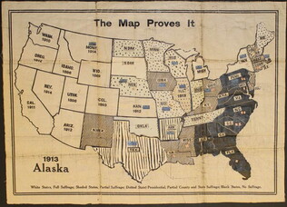
circa 1919
unknown, fl. 1919;
The Map Proves It [Women's suffrage map]
One map entitled "The Map Proves it" published circa 1919. This map illustrates the United States with different shading and colorizations of each state. The patterns and colors illustrate the status of the states in regards to women's suffrage...
GLC09773
18 July 1948
Roosevelt, Eleanor, (1884-1962)
Remarks by Mrs. [Eleanor] Roosevelt to the Seminar Group at Hyde Park, Sunday, July 18, 1948
One speech entitled "Remarks by Mrs. [Eleanor] Roosevelt to the Seminar Group at Hyde Park, Sunday, July 18, 1948." The speech concerns, the drafting, creation, and implementation of the Covenant on Human Rights. She discusses the difficulties in...
GLC09926
1890
Bien, Julius, (fl. 1890)
Proportion of the Colored to the Aggregate Population: 1890
JB00597
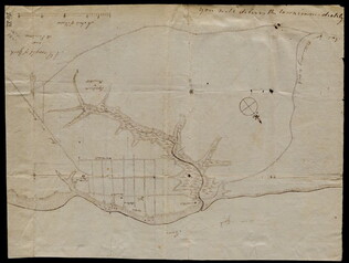
circa November 1813
Gwinnett, Button, 1735-1777
[Map of Button Gwinnett's estate]
Hand sketched map of Gwinnett's estate in Georgia of 1450 acres showing the bordering properties. Mentions neighboring properties of James Spalding and Mary Maxwell. Circa date from typed label originally accompanying the document upon acquisition.
GLC00658.02
Hoyer & Ludwig, fl. 1860
New map of Virginia
Folding map with Jackson's (Stonewall) signature "T.J. Jackson" on the inside of what was once the outer wrapper/binding. Insets of Harpers Ferry and Norfolk Harbor. The map was printed by J.W. Randolph, drawn and colored by Husted & Nenning, and...
GLC00612.01
circa 25 December 1864
Tower, Zealous Bates, 1819-1900
[Pencil illustration depicting the area near Nashville, Tennessee]
Autograph map depicts roads, rivers, fortifications and estimated troop numbers and locations near Nashville. Tower, chief engineer of Union defenses at Nashville, possibly transmitted this map with a letter (refer to GLC00849.01) to William P...
GLC00849.02
December 25, 1864
Battles before Nashville 15 & 16 December 1864 between U. S. Army commanded by Major Gen'l G. H. Thomas and Rebel Forces under Gen'l Hood
Autograph (lithograph) map entitled "Battles before Nashville 15 & 16 December 1864 between U. S. Army commanded by Major Gen'l G. H. Thomas and Rebel Forces under Gen'l Hood." Tower, chief engineer of Union defenses at Nashville, possibly...
GLC00849.03
10 January 1774
Dunn, Samuel, fl. 1774
North America as divided amongst the European powers
From The American Military Pocket Atlas (London, 1776), used by the British forces in the American Revolutionary War. "39" written on top right and bottom right corner of map. Reference numbers: Lowery 563. Phillips, Atlases 1206.
GLC02373
24 February 1862
Jordan, F.H., fl. 1862
[Manuscript Civil War map of the site of the Battle of Shiloh]
Entitled on docket: "Sketch of County embraced in a Reconnoissance made by Capt. F.H. Jordan." Also has a "Table of Distances." Pencilled "No. 2" on the front. An additional docket reads : "Jackson. Tenn March 20 [or 2d] 1862." Shows the Tennessee...
GLC02333
30 September 1844
Pelham, William, 1803-1879
[Arkansas survey map depicting land claims]
Depicts a map of the Arkansas surveying district "shewing the extent of Public Survey's in said district on the 30th September 1844." Contains boundary lines, including the Cherokee and Choctaw line, the Louisiana Line, the Missouri line, and the...
GLC02210.02
July 1864
Sneden, Robert Knox, 1832-1918
Plan of Andersonville Prison
Plan of the prison camp drawn by Sneden, a member of the 40th New York Volunteers imprisoned there in 1863-1864. Completed in ink and colored pencil. Sneden's map differs from other contemporary sketches.
GLC02244
3 August 1781
Lincoln, Benjamin, 1733-1810
[Map of Charleston, South Carolina]
Manuscript map of Charleston, South Carolina showing the coastline, various rivers and geographic features, certain structures and county names. Date and creator inferred, based on the presumption that this map accompanies GLC02437.01112.
GLC02437.01113
October 1781
[Map of Yorktown, Virginia]
Drawn map of Yorktown, Virginia. Shows roads, rivers, and other land markings, but not fortifications. With Cornwallis autograph note written across the front: "you will deliver the town immediately." Likely created by the British right before the...
GLC02437.10669
1847
M., Murguia, fl. 1847
[Map of the part of the valley of Mexico which has been a field of battle]
Black-inked lithograph map of Mexico with route of armies in brown, blue and green inks. Denotes military travel during August and September of 1847. On back, note by Wellington Cleveland Burnett explaining locations. On front, cardinal directions...
GLC00155.02
Sayer, Robert, 1725-1794
The American military pocket atlas; being an approved collection of correct maps
First issue in original boards, rebacked. Bookplate of Arthur Haynsworth Masten; ticket of T. Connolly, Bookseller, Dublin. Also with bookplate of Arthur Haynsworth Masten and inscription of "Jimmy [?] Browne / Augt. 1843" on titlepage. Full title...
GLC00257
1754 circa
Washington, George, 1732-1799
Map of the western parts of the colony of Virginia, as far as the Mississip[p]i
Rare folding map of Eastern part of what is today the United States to the Mississippi River. With orange color supplied on the borders of Virginia. Shows Washington's route from Williamsburg to French Fort. Removed from book due to condition 1997.
GLC00419.02
29 December 1862
Meister, C., fl. 1862
[Manuscript Civil War map of Murfreesboro, Tennessee]
Shows Murfreesboro and the areas north and west of it, along with names of property owners. Drawn shortly before the Battle of Stones River (Murfreesboro), providing evidence that General Braxton Bragg originally planned to attack the Union forces...
GLC02588
19 December 1862
Briscoe, James C., ?-1869
Position held by the 1st Divn. 3rd Corps After Having Repulsed the Enemy Decb. 13th 1862
Map sent with a letter written by Union General David B. Birney (see GLC02630.01). Shows the Union position on the battlefield at the Battle of Fredericksburg. Various picket lines, topographical features, and the locations of troops under generals...
GLC02630.02
1863-1865
Hoyt, Frank A., fl. 1863-1865
[Manuscript drawing of the camp of the 3rd Wisconsin Cavalry Regiment]
Shows the various buildings and structures in camp, including barracks, a sawmill, barns, and a steam furnace. The buildings are numbered and there is a corresponding legend on the verso. Drawn in pencil with a colored flag. The regiment operated...
GLC03050
1780
A Chart of New York Harbour
Not in Nebenzahl "Battle Plans of the American Revolution."
GLC03103.08
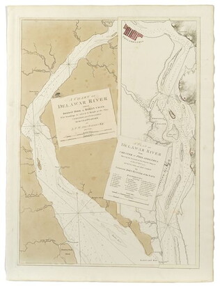
A Chart of the Delawar [Delaware] River, etc. with military key
Two views of the upper and lower river, showing the place of Philadelphia on it. Surveys from 1777. Nebenzahl, Battle Plans of the American Revolution, 136.
GLC03103.10
The Harbour of Charlestown [Charleston] in South Carolina
With a view of the city from the south side. Not in Nebenzahl, Battle Plans of the American Revolution.
GLC03103.11
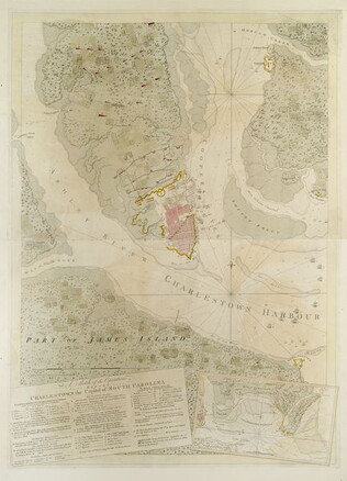
A Sketch of the environs of Charlestown [Charleston] in South Carolina
The key provides military information. Nebenzahl, Battle Plans of the American Revolution, 79, who notes a later state.
GLC03103.12
A Sketch of the operations before Charlestown [Charleston, S.C.]....
The key provides detailed military information. Nebenzahl, Battle Plans of the American Revolution, 136.
GLC03103.13
A Sketch of the battle near Camden in South Carolina, August 16, 1780
Nebenzahl, Battle Plans of the American Revolution, 89, who notes that the order of battle is correct while the terrain appears to be inaccurate.
GLC03103.14
Showing results 51 - 100