Self-Paced Courses: Explore American history with top historians at your own time and pace!
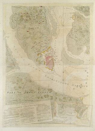
1780
Barres, Joseph Frederick Wallet des (1722-1824)
A Sketch of the operations before Charlestown [Charleston, S.C.]....
The key provides detailed military information. Nebenzahl, Battle Plans of the American Revolution, 136.
GLC03103.13
A Sketch of the battle near Camden in South Carolina, August 16, 1780
Nebenzahl, Battle Plans of the American Revolution, 89, who notes that the order of battle is correct while the terrain appears to be inaccurate.
GLC03103.14
Untitled chart of the coast of Georgia and South Carolina [Savannah]
Includes small plan of the siege of Savannah in a cartouche.
GLC03103.15
1714/08/18
Unknown
Manuscript map [in Dutch]
Most likely a section of Livingston's Manor, as Roeloff Jansen's Kill runs through the middle of it. Docket reads: Jurian Deckers Folly.
GLC03107.01088
20 July 1863-15 May 1864
Simpson, Edward (1824-1888)
Diary of Lt. Commander Edward Simpson
Diary of captaincy of the "Submarine Battery 'Passaic'". Details attacks upon Charleston, Fort Moultrie and Battery Gregg; inner workings of a Monitor and intraservice rivalries. Quarter calf, marbled boards, pencil loops.
The USS Passaic, one of...
GLC05911.04
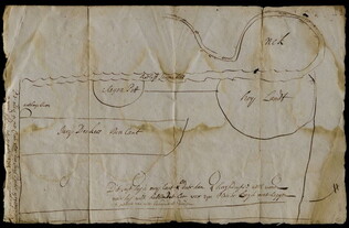
June 1864
Bartelle, Charles V. (fl. 1864)
Sketch showing defences and channels of Charleston Harbor.
This document is a map of Charleston Harbor depicting the major waterways and various forts in the area, among these is Fort Sumter. On the map it states that the map has been, "Copied by direction of Rear Admiral J. A. Dahlgren." The water on the...
GLC05919
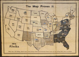
circa 1919
unknown, fl. 1919;
The Map Proves It [Women's suffrage map]
One map entitled "The Map Proves it" published circa 1919. This map illustrates the United States with different shading and colorizations of each state. The patterns and colors illustrate the status of the states in regards to women's suffrage...
GLC09773
1957
Smith, Karl, (fl. 1938-1959)
A Map of the United States 1492-1783
One map illustrated by Karl Smith and published by Linweave Quality Papers, and Chicago Paper Company in 1957. The map features the United States as it was from 1492-1783. It includes the borders of the new states at the close of the American...
GLC09861.01
1958
A Map of the United States 1784-1844
One map illustrated by Karl Smith and published by Linweave Quality Papers, and Chicago Paper Company in 1958. The map features the United States as it was from 1784-1844. It includes the borders after the Louisiana Purchase in green. In yellow is...
GLC09861.02
1959
A Map of the United States 1845-1866
One map illustrated by Karl Smith and published by Linweave Quality Papers, and Chicago Paper Company in 1959. The map features the United States as it was from 1845-1866. It includes the borders after the Civil War outlined in green. Shaded in green...
GLC09861.03
Showing results 441 - 450