Self-Paced Courses: Explore American history with top historians at your own time and pace!
1780
Barres, Joseph Frederick Wallet des (1722-1824)
Untitled chart of the coast of Georgia and South Carolina [Savannah]
Includes small plan of the siege of Savannah in a cartouche.
GLC03103.15
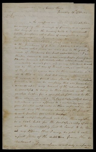
19 January 1780
Greene, Nathanael (1742-1786)
to James Abeel
Circular letter written to Abeel, the Deputy Quartermaster General of the Continental Army, about changes in the quartermaster's department. Indicates that the arrangement of financial business by Congress makes it necessary for them (as well as...
GLC05871
17 March 1777
Whipple, William (1730-1785)
to Josiah Bartlett
Discusses Continental troop movements, specifically regarding Fort Ticonderoga and New Jersey. Also, rising cost of living and collapsing currency, taxation, Franklin's reception at Versailles, and New Hampshire politics.
GLC05878
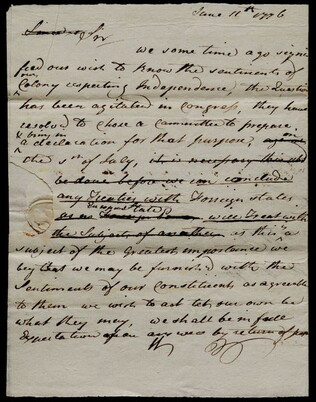
11 June 1776
[to Meshech Weare]
Signed "W." by Whipple and "B", by fellow New Hampshire congressman Josiah Bartlett. Asks for New Hampshire's views on the question of independence and states that a committee is being formed for this purpose. Stresses the importance of this...
GLC05897
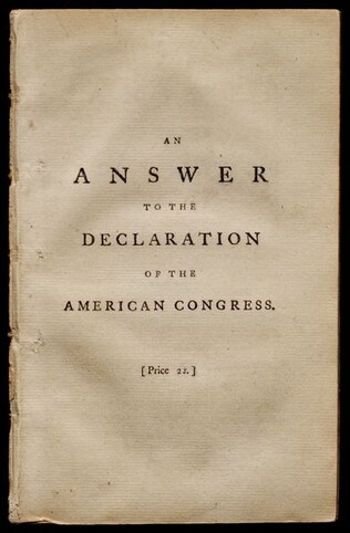
1776
Lind, John (fl. 1776)
An Answer to the declaration of the American Congress
Disbound. Printed by T. Cadell, J. Walter & T. Sewell. 1st edition. Response to the Declaration of Independence.
GLC05933
Putnam, George Palmer, (1814-1872)
Charleston, S.C. in 1780
One engraving entitled, "Charleston, S.C. in 1780," published in 1850. Depicts a view of the Charleston Customs House and port. The customs house was at the center of Charleston, South Carolina's bustling trade in rice, indigo, and slaves. Engraved...
GLC08878.0056.01
13 June 1781
Bailey, Francis (fl. 1781)
The Freeman's Journal [No. 8 (June 13, 1781)]
One issue of The Freeman's Journal dated June 13, 1781. Features an article concerning the passage of a bill connected to the gradual abolition of slavery that would re enslave people that were already freed in Westmorland County. There are also...
GLC09791.15
1770
Rollos, George, (fl. 1770)
An Accurate Map of Africa Drawn from the Sieur Robert with Improvements
One map entitled An Accurate Map of Africa Drawn from the Sieur Robert with Improvements, dated 1770. Contains the entire continent of Africa, as well as a small portion of the Middle East. The island of Madagascar is also included. The map notes...
GLC09862.02
Declaration of Independence
Declaration of Independence [book printing]: The remembrancer....
GLC01730.01
Volume 2
GLC01730.02
Showing results 5661 - 5670