Meet the 2024 History Teachers of the Year!
May 1944
U.S. Army
Defences Lessay
A two-sided map of the defences of Lessay, France. The front shows the map itself, while the back has a large ledgend.
GLC09557.04
1943
Port en Bessin to Cherbourg [and] Entretat to Port Bessin
A two-sided map of the coastline of France. One side of the map shows the Port en Bessin to Cherbourg and the reverse side shows Entretat to Port Bessin. This map has three hole punches and is labled page 185 and 186, but the rest of the book or...
GLC09557.05
ca. 1944
[Allied invasion of Normandy sectors]
A map of the five areas where Allied troops invaded Normandy on June 6, 1944.
GLC09557.06
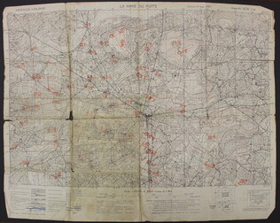
September 1943
La Haye du Puits [French]
A map of La Haye-du-Puits, France. There are numbers handwritten in orange on the map, but it is unclear what they represent. The back of the map has "La Haye Du Puits 31/18 S.W.," written in red.
GLC09557.07
1940-1946
Cleartype Maps
[Cleartype General Map of the Pacific Ocean, Southeastern Asia, and Austrailia]
A map of the Pacific Ocean, Southeastern Asia and Austrailia. Copyright the American Map Company Inc. Originally published by Cleartype Maps. Contains Robert L. Stone's notes on where he traveled when he was deployed.
GLC09620.251
Showing results 6 - 10