Meet the 2024 History Teachers of the Year!
1794/05/14
Whittle, & Laurie, fl. 1759
A new and general map of the middle dominion belonging to the United States...
The map shows part of the United States, from western New England to Michigan, and from Vermont to southern Virginia.
GLC04178
1864
Bacon & Company (San Francisco, Calif.)
Bacon's Large Print War Map Showing 50 Miles round Washington and Richmond
Shows major towns, waterways, and railroads. Concentric circles with intervals of ten miles each surround both Washington and Richmond. A red line shows General Ulysses S. Grant's route from Fredericksburg to Petersburg, Virginia, and a blue line...
GLC04175
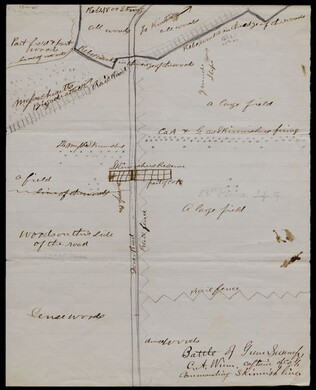
1863/05/23
Winn, Charles A., fl. 1863
[Battle of Gum Swamp]
Shows the Confederate and Union lines, the locations of a Massachusetts brigade attack and other skirmishes, and the arrangement of fields, woods, roads, and fences. Captain Winn, of Company G in the 58th Pennsylvania Infantry, commanded the skirmish...
GLC04158
1826
Finley, Anthony, fl. 1826
A New American atlas... [fifteen copper-plate engraved maps]
Anthony Finley publisher and putative compiler. Folio volume. Includes maps of the United States ("Map of the United States Constructed," New York, Ohio, Missouri, and the different regions of America. Period hand-color.
GLC04173
1857
Wells, John G., 1821-1880
Well's new map of Missouri and Eastern Kansas
This is a fold out map contained within a book measuring 14.5 x 9 cm. When unfolded, the full title displayed on the map is "Well's New Railroad and Township Map of Missouri and Eastern Kansas from the latest Government Surveys." Contains a large...
GLC04174
1776
Pownall, Thomas, 1722-1805
A topographical description of such parts of North America... [with] Map
With "A Map of the Middle British Colonies in North America... 1776." Not in Nebenzahl, Battle Plans of the American Revolution, but 41 (Sayer & Bennett, American Military Pocket Atlas, no.3) is based on these maps.
GLC04176
1846
J.H., Colton, & Co. (publishers), fl. 1856
Map of the United States, Mexico, and the West Indies, with parts adjoining
This document is a map of the United States, Mexico, and Caribbean territories belonging to George Cadwalader. Includes original holding case with "Cadwalader" inscription, which resembles a small book with a white binding ribbon. Map folds to 11.2 x...
GLC04577
Stephens, Ashbury L., 1843-?
[Manuscript Civil War map of General Sherman's Atlanta campaign]
Shows the route of Sherman's march from Chattanooga, Tennessee starting on 4 May 1864 and culminating with the siege of Atlanta on 8 September 1864. Drawn in black, red, yellow, and green ink on linen.
GLC04498.01
1776/03/12
Dury, Andrew, fl. 1775-1776
A Plan of Boston and its Environs... [siege of Boston]
Nebenzahl, Battle Plans of the American Revolution, 16.
GLC04410
1775/11/27
Sayer, Robert, 1725-1794
A Plan of the Battle on Bunkers Hill [Boston]
Nebenzahl, Battle Plans of the American Revolution, 28.
GLC04411
1786/08/15
A Map of the Whole Continent of America... [Wall Map on 4 sheets]
GLC04412.01
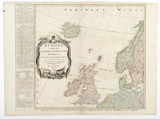
1787/01/01
Europe divided into its Empires, Kingdoms, States... [Wall Map on 4 sheets]
This map has an attractive depiction of Algiers and the Barbery states which is slightly larger than that for GLC# 4412.04 (Africa)
GLC04412.02
1787/01/06
Asia and its islands, according to D'Anville... [Wall Map on 4 sheets]
GLC04412.03
Africa with all its states, kingdoms... by S. Boulton [Wall Map on 4 sheets]
GLC04412.04
June 1864
Bartelle, Charles V., fl. 1864
Sketch showing defences and channels of Charleston Harbor.
This document is a map of Charleston Harbor depicting the major waterways and various forts in the area, among these is Fort Sumter. On the map it states that the map has been, "Copied by direction of Rear Admiral J. A. Dahlgren." The water on the...
GLC05919
1861
Colton, Joseph Hutchins, 1800-1893
Colton's Plans Of U.S. Harbors Showing The Position & Vicinities Of The Most Important Fortifications On The Sea-Board And In The Interior. From U.S. Surveys and other authentic sources.
Printed and folded twenty one panel Civil War map marked "No. 5." Bound in a booklet listing major administration officials and generals on the inside cover, both Union and Confederate. Shows the Mississippi River from New Orleans to Cairo...
GLC06157.06
1792
Ellicott, Andrew, fl. 1792
[Map of Washington, D.C.].
Engraved folding map removed from the "Columbian Magazine." Included with a letter from Thomas Jefferson to Charles W. Dumas (GLC07104.01).
GLC07104.02
1863
Jenney, William Le Baron, 1832-1907
[Civil War map of Mississippi and Alabama]
Covers northern segments of the two states, showing towns, watercourses, railroads, and roads. Also shows Corinth and vicinity. The Tennessee River appears prominently, colored with a light blue paint wash. The map is painted and drawn on a coated...
GLC07086.03
circa 1861
Klosterman, H., fl. 1861
Map of the Seat of War in South Carolina
Shows the Atlantic coast from Savannah to Winyaw Bay, with Charleston featured prominently in the lower center. Indicates towns, roads, and some topographical features. Painted and drawn on a coated, fine weave "architect's" linen. Mostly black...
GLC07086.04
May 1862
[Confederate Civil War map of the Army of Mississippi camp at Corinth, Mississippi]
Manuscript map shows the lines of entrenchments and reinforcements, the Danville Road, cultivated land, camp roads, a cotton press, the O & M Railroad and C & M Railroad, and General William J. Hardee's headquarters. Map was blind stamped while...
GLC05668
8 January 1777
[Map of roads in the vicinity of Morristown, New Jersey]
Indicates roads, some natural features, landmarks ("court house," "Whites Tavern Genl Lees," bridge, landing, etc.), outlying towns, and distance between points on the map. Indicates the location of towns surrounding Morristown. Notes the position...
GLC02437.09543
circa 1863-1864
Meigs, John R., fl. 1850-1864
[Maps of areas surrounding Staunton and Harrisonburg]
Hand-drawn maps in blue and red pencil of areas surrounding Staunton and Harrisonburg, Virginia.
GLC07059.17
[1863-1864]
Hand-drawn map in blue and red pencil, including towns of Newmarket, Hawkinsburg, and Woodstock.
Note on verso reads: "Field notes and maps found in pocket of J.R.M."
GLC07059.18
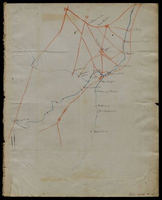
[Hand-drawn map]
Hand-drawn map in red and blue pencil.
GLC07059.19
22 July 1864
[Manuscript Civil War map of the position of the 2nd Division, 16th Army Corps in the Battle of Atlanta]
Shows the Confederate line, the positions of Union brigades, and a skirmish in the Battle of Atlanta. The legend indicates the positions at the beginning of the battle, the charging that occurred ("Rebel line charging") and the new line that was...
GLC04498.02
Showing results 26 - 50