The Gettysburg College–Gilder Lehrman MA in American History: Apply now and join us for Fall 2024 courses
1792
Ellicott, Andrew, fl. 1792
[Map of Washington, D.C.].
Engraved folding map removed from the "Columbian Magazine." Included with a letter from Thomas Jefferson to Charles W. Dumas (GLC07104.01).
GLC07104.02
1865
Sherman, William T. (William Tecumseh), 1820-1891
Military Map Showing the Marches of the United States Forces Under Command of Maj. Genl. W.T. Sherman, U.S.A. During the Years 1863, 1864, 1865
Black and white map ranging from Missouri to Maryland in the north and Louisiana to Georgia in the south. Sherman's routes are outlined in red, blue, green, yellow and brown. Compiled according to Sherman's order by Brevet Major W.L.B Jenney, and...
GLC07086.01
21 November 1863
West, Preston F., fl. 1863
No. 5 Map of Chattanooga and Vicinity
The title continues: "Compiled from Surveys and Information Under the Direction of Capt, W.E. Merrill U.S. Engrs. Chattanooga Nov 21st 1863." However, "Capt, W.E. Merrill U.S. Engrs" is crossed out and underneath is hand written: "Capt. Preston F...
GLC07086.02
1863
Jenney, William Le Baron, 1832-1907
[Civil War map of Mississippi and Alabama]
Covers northern segments of the two states, showing towns, watercourses, railroads, and roads. Also shows Corinth and vicinity. The Tennessee River appears prominently, colored with a light blue paint wash. The map is painted and drawn on a coated...
GLC07086.03
circa 1861
Klosterman, H., fl. 1861
Map of the Seat of War in South Carolina
Shows the Atlantic coast from Savannah to Winyaw Bay, with Charleston featured prominently in the lower center. Indicates towns, roads, and some topographical features. Painted and drawn on a coated, fine weave "architect's" linen. Mostly black...
GLC07086.04
12 June 1862
Blanchard, C. D., fl. 1862
[Manuscript Civil War map of the battleground of the Battle of Seven Pines]
Shows roads, streams, and some troop positions. Drawn on a scale of 200 paces or 133-1/3 yards to an inch. The Battle of Seven Pines took place on 31 May 1862-1 June 1862. Blanchard served as Chief Quartermaster, 4th Corps. Mostly black & white...
GLC06061.01
circa 1719-1721
Senex, John, fl. 1719-1721
A map of Louisiana and of the river Mississippi by John Senex
Engraved map of North America from Chesapeake Bay to the Rio del Norte. English version of the first map to show Texas, earlier land routes, and details of gulf region and the Mississippi. Original outline coloring. Scale: 1 inch = approximately 22...
GLC06090
1810
Arrowsmith, Aaron, 1750-1823
A new map of Mexico and adjacent provinces [roll map on linen]
A New Map of Mexico and Adjacent Provinces Compiled from Original Documents.... London: Published 5th. October 1810, by A. Arrowsmith, 10 Soho Sque. Hydrographer to His Majesty, 1810. Wall map, mounted on linen, with wooden rollers at top and bottom...
GLC06091
1856 ca.
To the free men of the North [election] [large cloth-backed lithographed map]
Free Labor Party abolitionist map used during the 1856 presidential campaign, printed, with hand-coloring in red, black and green.
GLC06662
February 1865
Aveleen, E. J., fl. 1865
[Manuscript Civil War map of the Confederate defenses around Sea Island, South Carolina]
Shows defenses between Secessionville and Fort Pringle, and down towards Forts Mahan and Delafield on Folly Island. James Island also appears. Shows the obstacles facing the Union's approach to Charleston, South Carolina in early 1865, including...
GLC06380
4 July 1863
Howard, Richard L., fl. 1863
[Map of the front view of Vicksburg]
Howard, Chaplain of the 124th Illinois Infantry, depicts Vicksburg, Mississippi and the surrounding area in black and red ink. Illustrates the Mississippi and Yazoo Rivers, a cottonwood forest, the Vicksburg and Texas Railroad line (destroyed)...
GLC06382.03
25 February 1777
Faden, William, fl. 1750-1836
A Plan of Operations... in New York... [Battle of White Plains]
First state with original handcolor. With C. Sauthier. "A plan of the operations of the King's army under the command of General Sir William Howe, K. B. in New York and East New Jersey, against the American Forces commanded by General Washington...
GLC06465
1870? ca.
Porter, Fitz-John, 1822-1901
Maps accompanying the proceedings of...the case of Fitz-John Porter [Atlas]
23 maps of Second Bull Run.
GLC07422
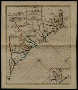
circa 1696
Sanson, Nicholas, 1600-1667
Carte generale de la Caroline dresse sur les memoirs le plus nouveaux
Map of North and South Carolina in an early period of settlement. Includes an inset of the area around Charleston, which locates plantations. This copy has a pencil note "1740" in margin, but no evidence for dating. In fact, this map remained...
GLC05236
12 March 1776
A Chart of Delaware Bay and River
Chart by Joshua Fisher. Depicts areas of Western New Jersey, Delaware, and Pennsylvania. There is extra shading on the shorelines of these states. Engraved by William Faden. Includes list of river pliots who subscribed to have it published. Slight...
GLC05237
1884
Royce, C. C., fl. 1884
Map of the former territorial limits of the Cherokee Nation of Indians
From the Fifth Annual Report printed by N. Peters. (Map printed by C.C. Royce.)
GLC05689
May 1862
[Confederate Civil War map of the Army of Mississippi camp at Corinth, Mississippi]
Manuscript map shows the lines of entrenchments and reinforcements, the Danville Road, cultivated land, camp roads, a cotton press, the O & M Railroad and C & M Railroad, and General William J. Hardee's headquarters. Map was blind stamped while...
GLC05668
1804/09/28
Krafft, C., fl. 1804
A View of Tripoli in Barbary
GLC07828
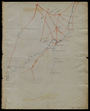
circa 1863-1864
Meigs, John R., fl. 1850-1864
[Maps of areas surrounding Staunton and Harrisonburg]
Hand-drawn maps in blue and red pencil of areas surrounding Staunton and Harrisonburg, Virginia.
GLC07059.17
[1863-1864]
Hand-drawn map in blue and red pencil, including towns of Newmarket, Hawkinsburg, and Woodstock.
Note on verso reads: "Field notes and maps found in pocket of J.R.M."
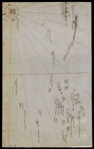
GLC07059.18
[Hand-drawn map]
Hand-drawn map in red and blue pencil.
GLC07059.19
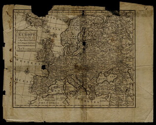
1758
Bennett, R., fl. 1758
Map of Europe describing its empires, kingdoms, and republics
GLC03107.05299
1856
Colton, Joseph Hutchins, 1800-1893
Map to illustrate Capt. Bonneville's adventures among the Rocky Mountains.
The map covers the western United States, with Washington, Oregon, California, Utah, New Mexico, Nebraska, Kansas, Texas, and Arkansas. Published in New York by George P. Putnam. Owned by John Moore (1826-1907), an army surgeon with the Utah...
GLC04194.01
circa July 1864
Stanley, Lucius T., 1844-1934
Battlefield Peach Tree Cr. Fought July 20 1864 Scale 4 in. pr. mi. from actual Survey by Topogs. of 1st Div 20 Corps
Notes houses, roads, military trails, locations of Union, including 1-3 Divisions of the 26th Corps and Confederate troops, lines of artillery, and barracks. Items are identifiable though the legend on the top of the map. Signed "Stanley fecit." Map...
GLC02710.35
[Union Civil War battlefield map of the Battle of Peachtree Creek]
Untitled draft of "Battlefield Peach Tree Cr. Fought July 20 1864 Scale 4 in. pr. mi. from actual Survey by Topogs. of 1st Div 20 Corps," found in GLC02710.35. Notes houses, Howel's Mill and Collier's Mill, a burned bridge, roads, and waterways...
GLC02710.36
circa May 1863
[Chancellorsville map showing Hooker, Jackson's attack, and site of the latter's death]
Shows Stonewall Jackson's route, his attack on the 11th Corps on 2 May 1863, and the "Place where Jackson was killed." Many annotations on reconnaissance, military activities, and places occupied by certain commanders, including Joseph Hooker. Shows...
GLC02710.37
circa 1864
Atlanta, and its rebel defences
Printed Civil War map from the Atlanta Campaign. Names major streets. The Fair Ground, Cemetery, the Locomotive House of the W & A Railroad, the Atlanta Steam Tannery, White Hall, and the headwaters of South River are indicated. The tracks for the...
GLC02710.38
circa 1818-1821
Gavit & Duthie, fl. 1840-1850
Map of the Frontiers of the Northern Colonies with the Boundary Line established Between them and the Indians at the Treaty held by S. Will Johnson at Ft. Stanwix in Novr. 1768.
This document is a map that shows the Colonies of New York, New Jersey, Maryland, Virginia, and the Ohio Valley Territory to the west of them. The map contains corrections and improvements from the Evans Map made by Guy Johnson, who was a British...
GLC05634.08
27 July 1841
Sarony & Co., 1854-1857
[Facsimile of map of New Netherlands using the names of Native American tribes to indicate location]
Printed on the bottom left corner is the signature of John Romeyn Brodhead, an agent of the State of New York hired to procure and transcribe documents in Europe. Signed by P.H. Loffelt, who copied this document for Brodhead in the Hague, and by J.C...
GLC05859.02
1861-1865
to Sarah Wood
Map of an unnamed town, with various houses identified.
GLC02176.42
Goss, Warren, fl. 1864-1880
Map of the prison
Map of the prison, with the locations of photographs # 1, 2, 4, 5, 6, 7 marked.
GLC06999.36
Map of the prison and surrounding areas.
GLC06999.37
1862
Abbot, Henry Larcom, 1831-1927
Campaign Maps Army of the Potomac, Map No. 1. Yorktown to Williamsburg [Manuscript map signed]
Title continues: "Prepared by Command of Maj. Gen. George B. Mc.Clellan U.S.A. Commd'g Army of the Potomac A.A. Humphreys Brig. Gen. and Chief of Top. Engr's." Accomplished on four pieces on joined wove paper. Photographed at the Coast Survey Office...
GLC04355.02
Campaign Maps Army of the Potomac, Map No. 1. Yorktown to Williamsburg
Title continues: "Prepared by Command of Maj. Gen. George B. Mc.Clellan U.S.A. Commanding Army of the Potomac Brig. Gen. A.A. Humphreys Chief of Top. Engrs Army of the Potomac." Engraved by W.H. Dougal. Map compiled by Abbot. Printed version of...
GLC04355.03
GLC04355.04
Campaign Map Army of the Potomac, Map No. 3. White House to Harrisons Landing
Title continues: "Prepared by Command of Maj. Gen. George B. Mc.Clellan U.S.A. Commd'g Army of the Potomac A.A. Humphreys Brig. Gen. and Chief of Top. Engr's." Map compiled by Abbot. Photographed at the Coast Survey Office. A very faint brown-line...
GLC04355.05
"Prepared by Command of Maj. Gen. George B. Mc.Clellan U.S.A. Commanding Army of the Potomac Brig. Gen. A.A. Humphreys Chief of Top. Engrs Army of the Potomac." Print engraved by W.H. Dougal. Map compiled by Abbot.
GLC04355.06
Campaign Maps Army of the Potomac, Map No. 2. Williamsburg to White House
Title continues: "Prepared by Command of Maj. Gen. George B. Mc.Clellan U.S.A. Commd'g Army of the Potomac A.A. Humphreys Brig. Gen. and Chief of Top. Engr's. Photographed at the Coast Survey Office. A faint brown-line print on four pieces of joined...
GLC04355.07
GLC04355.08
circa December 1862
Bush, George, fl. 1862
[Map of Fredericksburg]
A fairly complete and accurate map of the Union position at Fredericksburg. Shows federal positions, pontoon bridges, geographic features, roads and houses used as hospitals. The position held by Gibbon's Division is slightly exaggerated.
GLC03607.08
20 March 1862
Worret, Charles, 1819-?
[Manuscript map, Military Reconnaissance Dept. Va]
Title continues: "Major Genl. Wool Comdg. Drawn by Sergt. Worret & Compiled Under the Direction of Colonel T.J. Cram Chief Topl. Engr. Dept. Va." "Copy." Shows the Yorktown Peninsula and contains a description of the area in terms of its potential...
GLC04355.01
circa 1775-1776
[Battle plan for the siege of Boston Harbor]
Mapped battle plan for an American siege of Boston Harbor. Shows boats and some major geographic markers. For written plans see GLC02437.00231.
GLC02437.00232
10 June 1775
Montrésor, John, 1736-1799
A Map of the Province of New York with part of Pensylvania, and New England, from an actual survey by Captain Montrésor, Engineer, 1775
Includes insets of Connecticut River area and Lake Champlain area. Shows upper New York, Connecticut, Vermont. Framed to 92.7 x 113 cm. "P. Andreus, Sculpter" appears in lower right corner.
GLC03101.01
20 May 1834
United States. Congress
Map of the Western Territory & c.
Large folding map of present-day Oklahoma with borders outlined in watercolour designating areas occupied by Native American tribes. Map was previously bound in back of the House Report found in 4132.01. Border lines are colored in blue, yellow...
GLC04132.02
circa 1775
[Map of Lower New York State and surrounding areas]
Full title "To the Right Honourable Sir Jeffrey Amherst Knight of the Bath and Lieutenant General of his Majesty's forces etc., This map of the Province of New York is humbly Inscribed by His most obliged humble servant John Montresor, Engineer."...
GLC03101.02
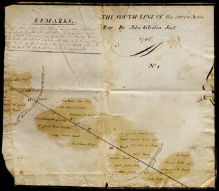
1795
Gleason, John, fl. 1796-1811
[Map of land]
Map of surveyed land possibly located in Maine. Titled, "THE SOUTH LINE OF the 50000 Acres Run By John Gleason Junr 1795 No 1." Covers three miles and a half of land and includes notes on the quality of land. Document is partially printed with...
GLC02437.10598
circa January 1863
Jones, Joseph, fl. 1862-1865
[Map of fortifications]
GLC02739.159
22 July 1864
Stephens, Ashbury L., 1843-?
[Manuscript Civil War map of the position of the 2nd Division, 16th Army Corps in the Battle of Atlanta]
Shows the Confederate line, the positions of Union brigades, and a skirmish in the Battle of Atlanta. The legend indicates the positions at the beginning of the battle, the charging that occurred ("Rebel line charging") and the new line that was...
GLC04498.02
27 July 1864
Snell, J.P., fl. 1864
[Manuscript Civil War map of the Battle of Atlanta]
Presented by Snell to Asbury Stephens, "one of the participants this 23d. day of Sept. 1864, at Eastpoint, Ga." Shows where the 2nd Brigade crossed the railroad, moved into battle, position at the works, and its efforts to repulse the Confederates...
GLC04498.03
8 October 1864
[Manuscript Civil War map of the Plan of Rome, Floyd County, Georgia]
Shows the locations of fortifications, a steam boat landing, and troop positions. Made two days before General Hood's army skirmished with General Sherman's supply line near Rome, causing Sherman's forces to fortify themselves in the town. Colored...
GLC04498.04
Showing results 201 - 250