The Gettysburg College–Gilder Lehrman MA in American History: Apply now and join us for Fall 2024 courses
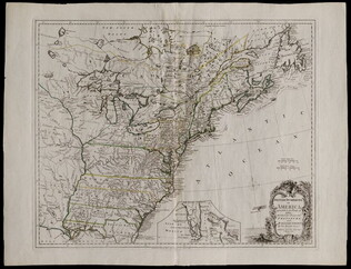
1777/06/17
Kitchin, Thomas, fl. 1750-1777
British dominions in America agreeable to the treaty of 1763...
With hand-colored outlines. Depicts the east coast of North America from New Foundland to Florida. Printed by Dury.
GLC05713
April 1862
[Field map made prior to the Civil War battles of Shiloh and Corinth]
This document is a manuscript map that shows major roads from Corinth to the Tennessee River, houses and their inhabitants, and occasionally their sympathies along the route. It also includes other topographical features. Drawn in pencil and brown...
GLC05759
June 1864
Bartelle, Charles V., fl. 1864
Sketch showing defences and channels of Charleston Harbor.
This document is a map of Charleston Harbor depicting the major waterways and various forts in the area, among these is Fort Sumter. On the map it states that the map has been, "Copied by direction of Rear Admiral J. A. Dahlgren." The water on the...
GLC05919
1863
Howell, R.H., fl. 1861-1863
Sea Coast of Georgia
Lithographed and published by Howell, cartographer unknown. Printed Civil War map showing the coastal area of Georgia from Florida to South Carolina. Marks railroads, canals, and major geographical points of interest. According the previous owner...
GLC05987.38
5 May 1862
Smith, Henry W., 1836-1869
[Manuscript Civil War map of the Battle of Williamsburg]
Shows the troop positions of forces under Union generals Philip Kearney and Joseph Hooker, as well as the Confederate line. Also shows the open field where the combatants met, Fort Magruder, and other structures. Smith is identified on the docket...
GLC06161
7 December 1862
Brooks, Alfred F., fl. 1862
[Manuscript Civil War map of the Battle of Murfreesboro]
Hand-colored map depicting Confederate and Union troop and artillery positions, and the location of a hospital. Brooks was the Acting Topographical Engineer, 2nd Brigade, 5th Division, 14 Army Corps.
GLC06162
1861
Colton, Joseph Hutchins, 1800-1893
Colton's Plans Of U.S. Harbors Showing The Position & Vicinities Of The Most Important Fortifications On The Sea-Board And In The Interior. From U.S. Surveys and other authentic sources.
Printed and folded twenty one panel Civil War map marked "No. 5." Bound in a booklet listing major administration officials and generals on the inside cover, both Union and Confederate. Shows the Mississippi River from New Orleans to Cairo...
GLC06157.06
12 June 1862
Blanchard, C. D., fl. 1862
[Manuscript Civil War map of the battleground of the Battle of Seven Pines]
Shows roads, streams, and some troop positions. Drawn on a scale of 200 paces or 133-1/3 yards to an inch. The Battle of Seven Pines took place on 31 May 1862-1 June 1862. Blanchard served as Chief Quartermaster, 4th Corps. Mostly black & white...
GLC06061.01
circa 1719-1721
Senex, John, fl. 1719-1721
A map of Louisiana and of the river Mississippi by John Senex
Engraved map of North America from Chesapeake Bay to the Rio del Norte. English version of the first map to show Texas, earlier land routes, and details of gulf region and the Mississippi. Original outline coloring. Scale: 1 inch = approximately 22...
GLC06090
1810
Arrowsmith, Aaron, 1750-1823
A new map of Mexico and adjacent provinces [roll map on linen]
A New Map of Mexico and Adjacent Provinces Compiled from Original Documents.... London: Published 5th. October 1810, by A. Arrowsmith, 10 Soho Sque. Hydrographer to His Majesty, 1810. Wall map, mounted on linen, with wooden rollers at top and bottom...
GLC06091
1856 ca.
To the free men of the North [election] [large cloth-backed lithographed map]
Free Labor Party abolitionist map used during the 1856 presidential campaign, printed, with hand-coloring in red, black and green.
GLC06662
February 1865
Aveleen, E. J., fl. 1865
[Manuscript Civil War map of the Confederate defenses around Sea Island, South Carolina]
Shows defenses between Secessionville and Fort Pringle, and down towards Forts Mahan and Delafield on Folly Island. James Island also appears. Shows the obstacles facing the Union's approach to Charleston, South Carolina in early 1865, including...
GLC06380
4 July 1863
Howard, Richard L., fl. 1863
[Map of the front view of Vicksburg]
Howard, Chaplain of the 124th Illinois Infantry, depicts Vicksburg, Mississippi and the surrounding area in black and red ink. Illustrates the Mississippi and Yazoo Rivers, a cottonwood forest, the Vicksburg and Texas Railroad line (destroyed)...
GLC06382.03
25 February 1777
Faden, William, fl. 1750-1836
A Plan of Operations... in New York... [Battle of White Plains]
First state with original handcolor. With C. Sauthier. "A plan of the operations of the King's army under the command of General Sir William Howe, K. B. in New York and East New Jersey, against the American Forces commanded by General Washington...
GLC06465
1870? ca.
Porter, Fitz-John, 1822-1901
Maps accompanying the proceedings of...the case of Fitz-John Porter [Atlas]
23 maps of Second Bull Run.
GLC07422
Showing results 601 - 615