The Gettysburg College–Gilder Lehrman MA in American History: Apply now and join us for Fall 2024 courses
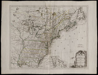
1777/06/17
Kitchin, Thomas, fl. 1750-1777
British dominions in America agreeable to the treaty of 1763...
With hand-colored outlines. Depicts the east coast of North America from New Foundland to Florida. Printed by Dury.
GLC05713
April 1862
[Field map made prior to the Civil War battles of Shiloh and Corinth]
This document is a manuscript map that shows major roads from Corinth to the Tennessee River, houses and their inhabitants, and occasionally their sympathies along the route. It also includes other topographical features. Drawn in pencil and brown...
GLC05759
1863
Howell, R.H., fl. 1861-1863
Sea Coast of Georgia
Lithographed and published by Howell, cartographer unknown. Printed Civil War map showing the coastal area of Georgia from Florida to South Carolina. Marks railroads, canals, and major geographical points of interest. According the previous owner...
GLC05987.38
5 May 1862
Smith, Henry W., 1836-1869
[Manuscript Civil War map of the Battle of Williamsburg]
Shows the troop positions of forces under Union generals Philip Kearney and Joseph Hooker, as well as the Confederate line. Also shows the open field where the combatants met, Fort Magruder, and other structures. Smith is identified on the docket...
GLC06161
7 December 1862
Brooks, Alfred F., fl. 1862
[Manuscript Civil War map of the Battle of Murfreesboro]
Hand-colored map depicting Confederate and Union troop and artillery positions, and the location of a hospital. Brooks was the Acting Topographical Engineer, 2nd Brigade, 5th Division, 14 Army Corps.
GLC06162
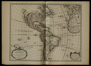
1722
De L'Isle, Guillaume, fl. 1718
Carte d'Amerique
Mercator projection including North and South America, with parts of Western Europe and Africa. Boundaries outlined in color. Shows North America from French perspective with English colonies restricted to the coast. Includes latitude and longitude...
GLC05238
1865
Sherman, William T. (William Tecumseh), 1820-1891
Military Map Showing the Marches of the United States Forces Under Command of Maj. Genl. W.T. Sherman, U.S.A. During the Years 1863, 1864, 1865
Black and white map ranging from Missouri to Maryland in the north and Louisiana to Georgia in the south. Sherman's routes are outlined in red, blue, green, yellow and brown. Compiled according to Sherman's order by Brevet Major W.L.B Jenney, and...
GLC07086.01
21 November 1863
West, Preston F., fl. 1863
No. 5 Map of Chattanooga and Vicinity
The title continues: "Compiled from Surveys and Information Under the Direction of Capt, W.E. Merrill U.S. Engrs. Chattanooga Nov 21st 1863." However, "Capt, W.E. Merrill U.S. Engrs" is crossed out and underneath is hand written: "Capt. Preston F...
GLC07086.02
12 June 1862
Blanchard, C. D., fl. 1862
[Manuscript Civil War map of the battleground of the Battle of Seven Pines]
Shows roads, streams, and some troop positions. Drawn on a scale of 200 paces or 133-1/3 yards to an inch. The Battle of Seven Pines took place on 31 May 1862-1 June 1862. Blanchard served as Chief Quartermaster, 4th Corps. Mostly black & white...
GLC06061.01
circa 1719-1721
Senex, John, fl. 1719-1721
A map of Louisiana and of the river Mississippi by John Senex
Engraved map of North America from Chesapeake Bay to the Rio del Norte. English version of the first map to show Texas, earlier land routes, and details of gulf region and the Mississippi. Original outline coloring. Scale: 1 inch = approximately 22...
GLC06090
Showing results 71 - 80