Meet the 2024 History Teachers of the Year!
1794/05/14
Whittle, & Laurie, fl. 1759
A new and general map of the middle dominion belonging to the United States...
The map shows part of the United States, from western New England to Michigan, and from Vermont to southern Virginia.
GLC04178
1864
Bacon & Company (San Francisco, Calif.)
Bacon's Large Print War Map Showing 50 Miles round Washington and Richmond
Shows major towns, waterways, and railroads. Concentric circles with intervals of ten miles each surround both Washington and Richmond. A red line shows General Ulysses S. Grant's route from Fredericksburg to Petersburg, Virginia, and a blue line...
GLC04175
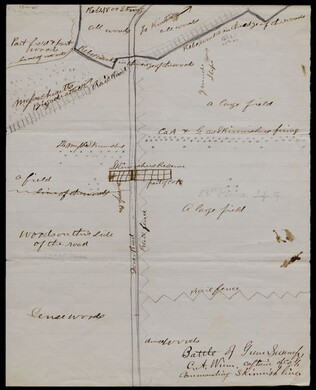
1863/05/23
Winn, Charles A., fl. 1863
[Battle of Gum Swamp]
Shows the Confederate and Union lines, the locations of a Massachusetts brigade attack and other skirmishes, and the arrangement of fields, woods, roads, and fences. Captain Winn, of Company G in the 58th Pennsylvania Infantry, commanded the skirmish...
GLC04158
1826
Finley, Anthony, fl. 1826
A New American atlas... [fifteen copper-plate engraved maps]
Anthony Finley publisher and putative compiler. Folio volume. Includes maps of the United States ("Map of the United States Constructed," New York, Ohio, Missouri, and the different regions of America. Period hand-color.
GLC04173
1857
Wells, John G., 1821-1880
Well's new map of Missouri and Eastern Kansas
This is a fold out map contained within a book measuring 14.5 x 9 cm. When unfolded, the full title displayed on the map is "Well's New Railroad and Township Map of Missouri and Eastern Kansas from the latest Government Surveys." Contains a large...
GLC04174
Showing results 26 - 30