The Gettysburg College–Gilder Lehrman MA in American History: Apply now and join us for Fall 2024 courses
1796/01/01
Arrowsmith, Aaron, 1750-1823
A Map of the United States of North America
Handcolored. Each sheet is 66 cm high. The map shows the northwest territory outside the Union. A portion of Louisiana is included.
GLC04318
1776/10/19
Faden, William, fl. 1750-1836
A Plan of New York island, with part of Long Island... [second issue]
Nebenzahl, Battle Plans of the American Revolution, 107. Second issue dated a month later than GLC 3533 (first issue). This map shows British control of Manhattan.
GLC04177
1794/05/14
Whittle, & Laurie, fl. 1759
A new and general map of the middle dominion belonging to the United States...
The map shows part of the United States, from western New England to Michigan, and from Vermont to southern Virginia.
GLC04178
1864
Bacon & Company (San Francisco, Calif.)
Bacon's Large Print War Map Showing 50 Miles round Washington and Richmond
Shows major towns, waterways, and railroads. Concentric circles with intervals of ten miles each surround both Washington and Richmond. A red line shows General Ulysses S. Grant's route from Fredericksburg to Petersburg, Virginia, and a blue line...
GLC04175
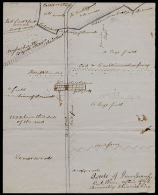
1863/05/23
Winn, Charles A., fl. 1863
[Battle of Gum Swamp]
Shows the Confederate and Union lines, the locations of a Massachusetts brigade attack and other skirmishes, and the arrangement of fields, woods, roads, and fences. Captain Winn, of Company G in the 58th Pennsylvania Infantry, commanded the skirmish...
GLC04158
Showing results 51 - 55