The Gettysburg College–Gilder Lehrman MA in American History: Apply now and join us for Fall 2024 courses
no date
Unknown
Map from Stratford to Poughkeepsie
This printed map appears to be cut out of a larger book or atlas. Neither Stratford nor Poughkeepsie is on the map. Has slight water damage/staining.
GLC02437.08401
circa December 1862
Bush, George (fl. 1862)
[Map of Fredericksburg]
A fairly complete and accurate map of the Union position at Fredericksburg. Shows federal positions, pontoon bridges, geographic features, roads and houses used as hospitals. The position held by Gibbon's Division is slightly exaggerated.
GLC03607.08
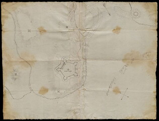
[rudimentary map of John Jackson's estate]
backside contains figures
GLC03769.008
Map of St. Augustine Harbor and Port
Map of St. Augustine Harbor and Port. San Sebastian River, North River, Matanzas River are pictured. Labels written in blue pen. Lighthouse Anastasia is labeled and drawn. Writing on verso specifies title of map.
GLC03974.40
1852
Horn, Hosea B. (fl. 1852)
Map to Illustrate Horn's Overland Guide to California and Oregon
Map originally attached to Horn's overland guide (housed with books, GLC 4152.01), from the U.S. Indian sub-agency, Council Bluffs, on the Missouri River, to the City of Sacramento, in California containing a table of distances, and showing all the...
GLC04152.02
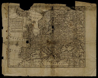
1758
Bennett, R. (fl. 1758)
Map of Europe describing its empires, kingdoms, and republics
GLC03107.05299
[n.d.]
Lincoln & Edmands
Book of maps
The maps include the world, Asia, Europe, Africa, North America, South America, and New England States.
GLC03107.05320
17 August 1900
unkown
Upper Silesia Plebiscite Area
Shows area of developed mineral resources, including coal bearing area. Also includes railways and district boundaries. Red line for final British proposal, Blue for French, and Green for League of Nations lines.
GLC02766.003
1831
Oberschlesien in Jahre [German]
Includes former and current boundaries.
GLC02766.005
Oberschlesien in der Gegenwart [German]
Upper Selesia.
GLC02766.006
Karte Von Schlesien [German]
Map of Selesia.
GLC02766.007
1871 - 1910
Bevolkerungsbewegung 1871 - 1910 [German]
Population Growth.
GLC02766.008
Upper-Silesian Plebiscite-Area
Final Results of the Plebiscite shown by districts.
GLC02766.009
Oberschlesien Deutche Zeit um 1350 [German]
Different regions in Silesia.
GLC02766.010
Oberschlesien [German]
From the Germanic up toward the end of of the Slavic Time in Silesia
GLC02766.012
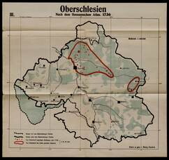
1730
Guckel, Marg (fl. 1730-)
Nach dem Homannschen Atlas 1730
GLC02766.013
1804
Bevolkerungsdichte von Oberschledien [German]
Population Density of Silesia.
GLC02766.014
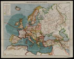
Flemming, Carl (fl. 1919-)
U-Boot-Kriegskate Von Europa [German]
U-Boat War Map
GLC02766.015
Map of Middle East
Includes railways and British Administration borders.
GLC02766.016
9 December 1801
Gleason, John (fl. 1796-1811)
[Copy of a survey map of land sold by Henry Knox to B. Joy of Boston]
Gleason and Robert Houston sign as surveyors. Depicts 16,340 acres of Waldo Patent land flanked by these notations: "Green, Waldo Heirs, Knox, Belfast, Northport, Lincolnville, and Bonapartte." A list of names is written in pencil within the area...
GLC02437.10341
23 July -6 August 1784
Galbraith, P. Bartrem (fl. 1784)
[Map of the Susquehanna River]
Drawn map of a portion of the Susquehanna River, with creeks, forts, and ferry landings noted. Also includes the distances to various points on the map. Noted as drawn above Canawago Falls, which is in Pennsylvania.
GLC02437.10583
1792
Pierpont, Joseph (fl. 1792)
[Map of land]
Map of the land by the Penobscot River. Water is drawn with blue watercolor ink. Shows the division of land into different plots.
GLC02437.10593
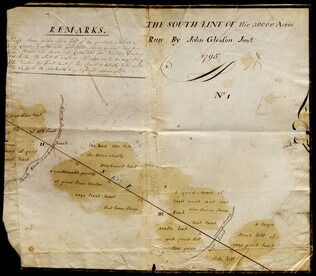
1795
Map of surveyed land possibly located in Maine. Titled, "THE SOUTH LINE OF the 50000 Acres Run By John Gleason Junr 1795 No 1." Covers three miles and a half of land and includes notes on the quality of land. Document is partially printed with...
GLC02437.10598
circa 1782
Erskine, Robert (1735-1780)
[Map of South Carolina]
A manuscript copy of a printed map of a portion of South Carolina. Shows lakes, rivers, streams, forest, towns, counties, and possibly roads. Noted, "Part of SOUTH CAROLINA copied by R. Erskine F. R. S. from A Map published in London 1771." Docket...
GLC02437.10611
30 March 1774
Flucker, Thomas (1719-1783)
A drawn map of land, likely located in Maine, deeded to Francis Waldo from Thomas and Hannah Flucker. Shows lakes, rivers, and boundary lines. Date taken from docket.
GLC02437.10645
4 July 1781
Storers, Christain (fl. 1781)
[Sketch of land]
Charles Miller signed the docket on 2 November 1801. A sketch of Christian Storers' surveyed land lying in "Waldowborough" [Waldoborough, Maine]. Includes written information regarding boundary lines and a drawn compass showing cardinal directions...
GLC02437.10646
circa 1796-1806
A sketch of land surveyed by John Gleason. Cover 50,000 acres of land likely located in Maine. Shows a pond and various land marks in water colors and has a partially colored border.
GLC02437.10650
circa 1784-1806
A drawn map of lands near the Penobscot River in Maine. Land is noted as belonging to the heirs of Brigadier [General Samuel] Waldo. Lakes and rivers are noted in blue water color. Includes a drawn compass showing cardinal directions.
GLC02437.10652
circa 1790
Noted as a copy. Drawn sketch of a plan for the northwestern part of the Waldo Patent located in Maine. Depicts county lines and the northern and western boundaries of the Waldo Patent. Date was added later in pencil.
GLC02437.10666
circa 1782-1783
Bauman, Sebastian (1739-1803)
[Map of Forts Ontario and Oswego and surroundings]
Docketed as "A rough sketch of Oswego by Major Bauman." Shows Fort Ontario (captioned), Fort Oswego (uncaptioned) and surrounding features (possibly earthworks).
GLC02437.10667
circa July 1864
Stanley, Lucius T. (1844-1934)
Battlefield Peach Tree Cr. Fought July 20 1864 Scale 4 in. pr. mi. from actual Survey by Topogs. of 1st Div 20 Corps
Notes houses, roads, military trails, locations of Union, including 1-3 Divisions of the 26th Corps and Confederate troops, lines of artillery, and barracks. Items are identifiable though the legend on the top of the map. Signed "Stanley fecit." Map...
GLC02710.35
[Union Civil War battlefield map of the Battle of Peachtree Creek]
Untitled draft of "Battlefield Peach Tree Cr. Fought July 20 1864 Scale 4 in. pr. mi. from actual Survey by Topogs. of 1st Div 20 Corps," found in GLC02710.35. Notes houses, Howel's Mill and Collier's Mill, a burned bridge, roads, and waterways...
GLC02710.36
circa May 1863
[Chancellorsville map showing Hooker, Jackson's attack, and site of the latter's death]
Shows Stonewall Jackson's route, his attack on the 11th Corps on 2 May 1863, and the "Place where Jackson was killed." Many annotations on reconnaissance, military activities, and places occupied by certain commanders, including Joseph Hooker. Shows...
GLC02710.37
circa 1864
Atlanta, and its rebel defences
Printed Civil War map from the Atlanta Campaign. Names major streets. The Fair Ground, Cemetery, the Locomotive House of the W & A Railroad, the Atlanta Steam Tannery, White Hall, and the headwaters of South River are indicated. The tracks for the...
GLC02710.38
February 1864
Jones, Joseph
[Fort of Sweetwater, Tennessee]
GLC02739.101
1865
General Benham's winter camp near Poplar Grove Church, Va., with photo of troops
Printed map, "Winter Camp, Detachment 50th N.Y.V. Engineers" Brevet Colonel I. Spalding Commanding, near Poplar Church, Virginia, Army of the Potomac, 1865. Has been partially hand colored. An original albumen photograph of soldiers with musical...
GLC00919.26
February 1782
Bauman, Sebastian, 1739-1803
Plan of the investment of York and Gloucester
Drafted at Washington's request, shortly after the battle of Yorktown, Virginia. Nebenzahl, Battle Plans of the American Revolution, 189, with references.
GLC01869
1779
Barres, Joseph Frederick Wallet des, 1722-1824
Plan of Fort Montgomery and Fort Clinton
From the Atlantic Neptune. Engraved and tinted map showing the Hudson River by Anthony's Nose with the Americans' chains across the river. Plate no. 19. (The map mistakenly calls the mountain "St. Anthony's Nose.") Nebenzahl, Battle Plans of the...
GLC01850
1784
Hills, John, fl. 1771-1796
Sketch of the position of the British forces at Elizabeth-Town Point
Original by John Hill. Oversize engraved map with hand coloring of troop positions. Engraved by Faden. Nebenzahl, Battle Plans of the American Revolution, 146.
GLC01858
1846
Preuss, Charles, fl. 1846
Topographical map of the road from Missouri to Oregon
Compiled by Charles Preuss, 1846, by command of the Senate. In Seven Sections. Scale 10 miles to the inch. Litho by E. Weber & Co., Baltimore.
GLC01873
1776
Brassier, William, fl. 1776
A survey of Lake Champlain, including Lake George, Crown Point... 1762
Includes (inset) "A particular plan of Lake George." The engraved map shows engagements between American and British forces on Lake Champlain. Not in Nebenzahl, Battle Plans of the American Revolution.
GLC01874
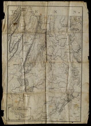
5 May 1864
Margedant, William C., 1835-?
Part of Northern Georgia
Printed "In the field" on cloth. Black and white lithograph depicts Northern Georgia. Compiled under the direction of William E. Merrill, Chief Topographical Engineer, Washington, D.C. Margedant was Captain and Superintendent of the Topographical...
GLC01740.06
2 May 1864
Merrill, W.E., 1837-1891
Map of Northern Georgia.
Created under the direction of Captain William E. Merrill, Chief Topographical Engineer. Lithographed map printed on paper squares mounted on cloth to facilitate folding. Contains handcoloring on roads and state borders. Based on Cherokee land maps...
GLC01740.02
1862
Nicholson, Walter L., ?-1895
Map of Eastern Virginia compiled from the best authorities, and printed at the Coast Survey Office.
Printed by the Coast Survey Office, compiled by Nicholson, and lithographed by Charles G. Krebs. Depicts eastern Virginia, Maryland and Delaware with portions of Pennsylvania, New Jersey, and North Carolina. Shows rail lines, rivers, and other...
GLC01740.03
1861
Colton, Joseph Hutchins, 1800-1893
Colton's new topographical map of the eastern portion of the State of North Carolina with part of Virginia and South Carolina, from the latest & best authorities.
Printed by Lang & Laing. Lithographed map with some hand-colored areas. Depicts eastern coastline of North Carolina with Atlantic Ocean and neighbone of North Carolina with Atlantic Ocean and neighboring states. According to a previous note, this...
GLC01740.04
15 November 1864-21 December 1864
Harris, Rodney E., fl. 1862-1865
Maps Showing the Campaign of the 20th Corps from Atlanta to Savannah with the Dates
Disbound booklet of ten chronological watercolor maps documenting the towns and cities General William T. Sherman passed through on his march to the sea, from Atlanta to Savannah, Georgia. At the end is a large manuscript account of the march...
GLC01888
1 November 1776
Hawkes, W., fl. 1776
The Country twenty-five miles round New York
Irregular shaped paper. Engraving with letterpress chronological table of events from 1773-Oct. 1776, engraved by J. Barber and printed by W. Hawkes. Irregularly shaped. Nebenzahl, Battle Plans of the American Revolution, 110, who notes that a later...
GLC02005
Ratzer, Bernard, 1700-?
Plan of the City of New York in North America
Engraved by Jeffrey and Fagan. Oversize engraving showing lower Manhattan Island, part of Brooklyn and Hoboken, N.J. A cartouche extending across the bottom has a panoramic "South West View of the City of New York." Based upon the survey of 1766...
GLC02006
[Manuscript Civil War map of Atlanta and vicinity]
Detailed map on blue lined paper of Atlanta and environs from General Sherman's Atlanta campaign. Shows roads, railroads, forests, and rivers. Directions and latitude not given.
GLC01924
1777
Faden, William, fl. 1750-1836
A Plan of the city and environs of Philadelphia
Surveyed by N. Scull and G. Heap, engraved by William Faden. Includes military information relative to the American Revolution. Also has an inset image of Independence Hall, where the Declaration of Independence was adopted.
GLC02118
Showing results 51 - 100