The Gettysburg College–Gilder Lehrman MA in American History: Apply now and join us for Fall 2024 courses
no date
Unknown
Map from Stratford to Poughkeepsie
This printed map appears to be cut out of a larger book or atlas. Neither Stratford nor Poughkeepsie is on the map. Has slight water damage/staining.
GLC02437.08401
circa December 1862
Bush, George (fl. 1862)
[Map of Fredericksburg]
A fairly complete and accurate map of the Union position at Fredericksburg. Shows federal positions, pontoon bridges, geographic features, roads and houses used as hospitals. The position held by Gibbon's Division is slightly exaggerated.
GLC03607.08
[rudimentary map of John Jackson's estate]
backside contains figures
GLC03769.008
Map of St. Augustine Harbor and Port
Map of St. Augustine Harbor and Port. San Sebastian River, North River, Matanzas River are pictured. Labels written in blue pen. Lighthouse Anastasia is labeled and drawn. Writing on verso specifies title of map.
GLC03974.40
1852
Horn, Hosea B. (fl. 1852)
Map to Illustrate Horn's Overland Guide to California and Oregon
Map originally attached to Horn's overland guide (housed with books, GLC 4152.01), from the U.S. Indian sub-agency, Council Bluffs, on the Missouri River, to the City of Sacramento, in California containing a table of distances, and showing all the...
GLC04152.02
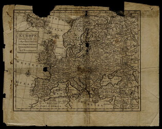
1758
Bennett, R. (fl. 1758)
Map of Europe describing its empires, kingdoms, and republics
GLC03107.05299
[n.d.]
Lincoln & Edmands
Book of maps
The maps include the world, Asia, Europe, Africa, North America, South America, and New England States.
GLC03107.05320
17 August 1900
unkown
Upper Silesia Plebiscite Area
Shows area of developed mineral resources, including coal bearing area. Also includes railways and district boundaries. Red line for final British proposal, Blue for French, and Green for League of Nations lines.
GLC02766.003
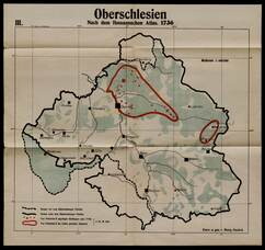
1831
Oberschlesien in Jahre [German]
Includes former and current boundaries.
GLC02766.005
Oberschlesien in der Gegenwart [German]
Upper Selesia.
GLC02766.006
Karte Von Schlesien [German]
Map of Selesia.
GLC02766.007
1871 - 1910
Bevolkerungsbewegung 1871 - 1910 [German]
Population Growth.
GLC02766.008
Upper-Silesian Plebiscite-Area
Final Results of the Plebiscite shown by districts.
GLC02766.009
Oberschlesien Deutche Zeit um 1350 [German]
Different regions in Silesia.
GLC02766.010
Oberschlesien [German]
From the Germanic up toward the end of of the Slavic Time in Silesia
GLC02766.012
1730
Guckel, Marg (fl. 1730-)
Nach dem Homannschen Atlas 1730
GLC02766.013
1804
Bevolkerungsdichte von Oberschledien [German]
Population Density of Silesia.
GLC02766.014
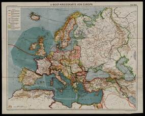
Flemming, Carl (fl. 1919-)
U-Boot-Kriegskate Von Europa [German]
U-Boat War Map
GLC02766.015
Map of Middle East
Includes railways and British Administration borders.
GLC02766.016
9 December 1801
Gleason, John (fl. 1796-1811)
[Copy of a survey map of land sold by Henry Knox to B. Joy of Boston]
Gleason and Robert Houston sign as surveyors. Depicts 16,340 acres of Waldo Patent land flanked by these notations: "Green, Waldo Heirs, Knox, Belfast, Northport, Lincolnville, and Bonapartte." A list of names is written in pencil within the area...
GLC02437.10341
23 July -6 August 1784
Galbraith, P. Bartrem (fl. 1784)
[Map of the Susquehanna River]
Drawn map of a portion of the Susquehanna River, with creeks, forts, and ferry landings noted. Also includes the distances to various points on the map. Noted as drawn above Canawago Falls, which is in Pennsylvania.
GLC02437.10583
1792
Pierpont, Joseph (fl. 1792)
[Map of land]
Map of the land by the Penobscot River. Water is drawn with blue watercolor ink. Shows the division of land into different plots.
GLC02437.10593
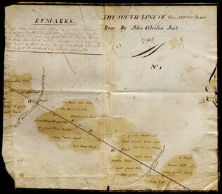
1795
Map of surveyed land possibly located in Maine. Titled, "THE SOUTH LINE OF the 50000 Acres Run By John Gleason Junr 1795 No 1." Covers three miles and a half of land and includes notes on the quality of land. Document is partially printed with...
GLC02437.10598
circa 1782
Erskine, Robert (1735-1780)
[Map of South Carolina]
A manuscript copy of a printed map of a portion of South Carolina. Shows lakes, rivers, streams, forest, towns, counties, and possibly roads. Noted, "Part of SOUTH CAROLINA copied by R. Erskine F. R. S. from A Map published in London 1771." Docket...
GLC02437.10611
30 March 1774
Flucker, Thomas (1719-1783)
A drawn map of land, likely located in Maine, deeded to Francis Waldo from Thomas and Hannah Flucker. Shows lakes, rivers, and boundary lines. Date taken from docket.
GLC02437.10645
Showing results 51 - 75