Meet the 2024 History Teachers of the Year!
30 March 1774
Flucker, Thomas, 1719-1783
[Map of land]
A drawn map of land, likely located in Maine, deeded to Francis Waldo from Thomas and Hannah Flucker. Shows lakes, rivers, and boundary lines. Date taken from docket.
GLC02437.10645
4 July 1781
Storers, Christian, fl. 1781
[Sketch of land]
Charles Miller signed the docket on 2 November 1801. A sketch of Christian Storers' surveyed land lying in "Waldowborough" [Waldoborough, Maine]. Includes written information regarding boundary lines and a drawn compass showing cardinal directions...
GLC02437.10646
circa 1796-1806
Gleason, John, fl. 1796-1811
A sketch of land surveyed by John Gleason. Cover 50,000 acres of land likely located in Maine. Shows a pond and various land marks in water colors and has a partially colored border.
GLC02437.10650
circa 1784-1806
A drawn map of lands near the Penobscot River in Maine. Land is noted as belonging to the heirs of Brigadier [General Samuel] Waldo. Lakes and rivers are noted in blue water color. Includes a drawn compass showing cardinal directions.
GLC02437.10652
circa 1790
Noted as a copy. Drawn sketch of a plan for the northwestern part of the Waldo Patent located in Maine. Depicts county lines and the northern and western boundaries of the Waldo Patent. Date was added later in pencil.
GLC02437.10666
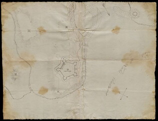
circa 1782-1783
Bauman, Sebastian, 1739-1803
[Map of Forts Ontario and Oswego and surroundings]
Docketed as "A rough sketch of Oswego by Major Bauman." Shows Fort Ontario (captioned), Fort Oswego (uncaptioned) and surrounding features (possibly earthworks).
GLC02437.10667
1861-1865
[Map of islands on the Sea of Okhotsk]
A hand-drawn map on linen of islands in the Sea of Okhotsk located on the coast of Russia between the Kamchatka Peninsula and Sakhalin Island. The map contains numbers throughout and depicts such places Big Shantar, Little Shantar, Bear Island, and...
GLC02016.181
1895
Powell, George May, 1835-1905
Powell's Light and Shade Relief Map of Palestine
GLC00687.092
1897
Radial Key Map of Palestine in the Time of Our Saviour
GLC00687.093
9 December 1801
[Copy of a survey map of land sold by Henry Knox to B. Joy of Boston]
Gleason and Robert Houston sign as surveyors. Depicts 16,340 acres of Waldo Patent land flanked by these notations: "Green, Waldo Heirs, Knox, Belfast, Northport, Lincolnville, and Bonapartte." A list of names is written in pencil within the area...
GLC02437.10341
Showing results 191 - 200