Meet the 2024 History Teachers of the Year!
1856 ca.
To the free men of the North [election] [large cloth-backed lithographed map]
Free Labor Party abolitionist map used during the 1856 presidential campaign, printed, with hand-coloring in red, black and green.
GLC06662
February 1865
Aveleen, E. J., fl. 1865
[Manuscript Civil War map of the Confederate defenses around Sea Island, South Carolina]
Shows defenses between Secessionville and Fort Pringle, and down towards Forts Mahan and Delafield on Folly Island. James Island also appears. Shows the obstacles facing the Union's approach to Charleston, South Carolina in early 1865, including...
GLC06380
4 July 1863
Howard, Richard L., fl. 1863
[Map of the front view of Vicksburg]
Howard, Chaplain of the 124th Illinois Infantry, depicts Vicksburg, Mississippi and the surrounding area in black and red ink. Illustrates the Mississippi and Yazoo Rivers, a cottonwood forest, the Vicksburg and Texas Railroad line (destroyed)...
GLC06382.03
25 February 1777
Faden, William, fl. 1750-1836
A Plan of Operations... in New York... [Battle of White Plains]
First state with original handcolor. With C. Sauthier. "A plan of the operations of the King's army under the command of General Sir William Howe, K. B. in New York and East New Jersey, against the American Forces commanded by General Washington...
GLC06465
1870? ca.
Porter, Fitz-John, 1822-1901
Maps accompanying the proceedings of...the case of Fitz-John Porter [Atlas]
23 maps of Second Bull Run.
GLC07422
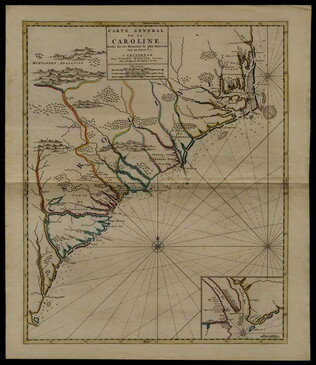
circa 1696
Sanson, Nicholas, 1600-1667
Carte generale de la Caroline dresse sur les memoirs le plus nouveaux
Map of North and South Carolina in an early period of settlement. Includes an inset of the area around Charleston, which locates plantations. This copy has a pencil note "1740" in margin, but no evidence for dating. In fact, this map remained...
GLC05236
12 March 1776
A Chart of Delaware Bay and River
Chart by Joshua Fisher. Depicts areas of Western New Jersey, Delaware, and Pennsylvania. There is extra shading on the shorelines of these states. Engraved by William Faden. Includes list of river pliots who subscribed to have it published. Slight...
GLC05237
1884
Royce, C. C., fl. 1884
Map of the former territorial limits of the Cherokee Nation of Indians
From the Fifth Annual Report printed by N. Peters. (Map printed by C.C. Royce.)
GLC05689
May 1862
[Confederate Civil War map of the Army of Mississippi camp at Corinth, Mississippi]
Manuscript map shows the lines of entrenchments and reinforcements, the Danville Road, cultivated land, camp roads, a cotton press, the O & M Railroad and C & M Railroad, and General William J. Hardee's headquarters. Map was blind stamped while...
GLC05668
1804/09/28
Krafft, C., fl. 1804
A View of Tripoli in Barbary
GLC07828
1861
Map of the seat of war to accompany the American conflict
Removed from Harper's Weekly, Vol. 8, 1864 (GLC01733.06).
GLC01733.16
8 January 1777
[Map of roads in the vicinity of Morristown, New Jersey]
Indicates roads, some natural features, landmarks ("court house," "Whites Tavern Genl Lees," bridge, landing, etc.), outlying towns, and distance between points on the map. Indicates the location of towns surrounding Morristown. Notes the position...
GLC02437.09543
1792
Pierpont, Joseph, fl. 1792
[Map of land]
Map of the land by the Penobscot River. Water is drawn with blue watercolor ink. Shows the division of land into different plots.
GLC02437.10593
23 July -6 August 1784
Galbraith, P. Bartrem, fl. 1784
[Map of the Susquehanna River]
Drawn map of a portion of the Susquehanna River, with creeks, forts, and ferry landings noted. Also includes the distances to various points on the map. Noted as drawn above Canawago Falls, which is in Pennsylvania.
GLC02437.10583
1830
Stone, W. J., fl. 1830
[Map of Northern Maine]
Map of northern Maine and adjacent British Provinces. Includes Great Britain's claims. Boundary lines between the United States, Great Britain, and the arbiter are color coded. Noted, "Reduced from the official Map A with latest surveys by S.L...
GLC02437.10609
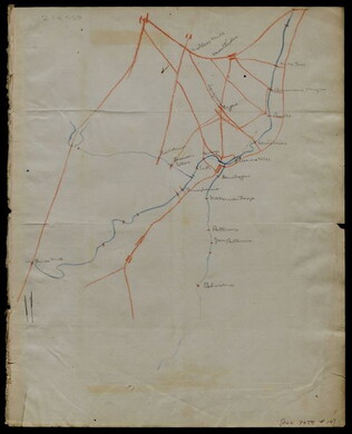
circa 1863-1864
Meigs, John R., fl. 1850-1864
[Maps of areas surrounding Staunton and Harrisonburg]
Hand-drawn maps in blue and red pencil of areas surrounding Staunton and Harrisonburg, Virginia.
GLC07059.17
[1863-1864]
Hand-drawn map in blue and red pencil, including towns of Newmarket, Hawkinsburg, and Woodstock.
Note on verso reads: "Field notes and maps found in pocket of J.R.M."
GLC07059.18
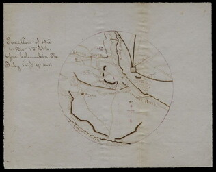
[Hand-drawn map]
Hand-drawn map in red and blue pencil.
GLC07059.19
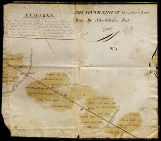
1795
Gleason, John, fl. 1796-1811
Map of surveyed land possibly located in Maine. Titled, "THE SOUTH LINE OF the 50000 Acres Run By John Gleason Junr 1795 No 1." Covers three miles and a half of land and includes notes on the quality of land. Document is partially printed with...
GLC02437.10598
circa January 1863
Jones, Joseph, fl. 1862-1865
[Map of fortifications]
GLC02739.159
22 July 1864
Stephens, Ashbury L., 1843-?
[Manuscript Civil War map of the position of the 2nd Division, 16th Army Corps in the Battle of Atlanta]
Shows the Confederate line, the positions of Union brigades, and a skirmish in the Battle of Atlanta. The legend indicates the positions at the beginning of the battle, the charging that occurred ("Rebel line charging") and the new line that was...
GLC04498.02
27 July 1864
Snell, J.P., fl. 1864
[Manuscript Civil War map of the Battle of Atlanta]
Presented by Snell to Asbury Stephens, "one of the participants this 23d. day of Sept. 1864, at Eastpoint, Ga." Shows where the 2nd Brigade crossed the railroad, moved into battle, position at the works, and its efforts to repulse the Confederates...
GLC04498.03
8 October 1864
[Manuscript Civil War map of the Plan of Rome, Floyd County, Georgia]
Shows the locations of fortifications, a steam boat landing, and troop positions. Made two days before General Hood's army skirmished with General Sherman's supply line near Rome, causing Sherman's forces to fortify themselves in the town. Colored...
GLC04498.04
[Manuscript Civil War map of the position of an army division at the Ogeecheee River in Georgia]
Shows the position of the 4th Division of the 15th Army Corps, the road to Savannah, the Confederate lines across the swamp. Also shows positions of various troops and General William T. Sherman's headquarters. Drawn in brown and pink ink a month...
GLC04498.05
[Manuscript Civil War map of the siege of Columbia, South Carolina]
Circular map showing the position of the 4th Division of the 13th Army Corps, rivers, railroads, and roads around Columbia. General Sherman's siege was on 16-17 February 1865. Drawn in brown and pink ink.
GLC04498.06
Showing results 126 - 150