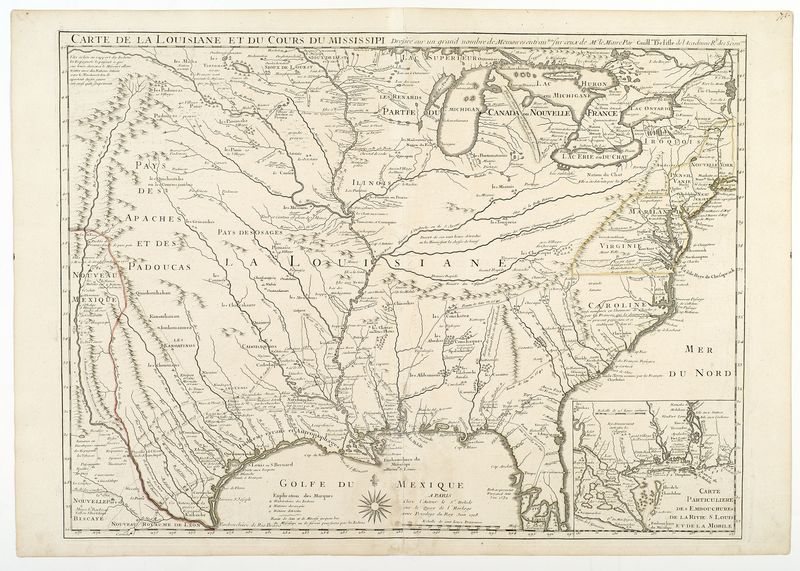
De L'Isle, Guillaume (fl. 1718-1722) Carte de la Louisiane et du cours du Mississippi [map of North America]
High-resolution images are available to schools and libraries via subscription to American History, 1493-1943. Check to see if your school or library already has a subscription. Or click here for more information. You may also order a pdf of the image from us here.
A high-resolution version of this object is available for registered users. LOG IN
Gilder Lehrman Collection #: GLC04222 Author/Creator: De L'Isle, Guillaume (fl. 1718-1722) Place Written: Paris Type: Map Date: 1718 Pagination: 1 sheet 65 x 50 cm Order a Copy PDF Download(s): Download PDF
Based on the notes of M. le Maire by Guillaume del'Isle. The first detailed map of the Gulf coast region and the Mississippi, and the first printed map to show Texas. With an insert of Mobile Bay. This map was also the first to show the land routes of earlier explorers: Desoto in 1539 and 1540 and his successor Moscoso in 1542, Cavelier in 1687, Tonty in 1702 and the recent routes of Denis in 1713 and 1716. The map's political implications outraged the English by laying claim to Carolina. Mapping of America 43.
Citation Guidelines for Online Resources
The copyright law of the United States (title 17, United States Code) governs the making of photocopies or other reproductions of copyrighted material. Under certain conditions specified in the law, libraries and archives are authorized to furnish a photocopy or other reproduction. One of these specific conditions is that the photocopy or reproduction is not to be “used for any purpose other than private study, scholarship, or research.” If a user makes a request for, or later uses, a photocopy or reproduction for purposes in excess of “fair use,” that user may be liable for copyright infringement. This institution reserves the right to refuse to accept a copying order if, in its judgment, fulfillment of the order would involve violation of copyright law.